
16.11.2023
10 min
1825

This article was made for research purposes. Gaza is one area that may seem difficult for open source researchers due to the quality of the satellite imagery, which has been appallingly poor and out of date. Diving into the Geolocation of the Gaza Aerospace War – This article offers an in-depth study and detailed analysis of the aerospace conflicts in the region. Using modern geolocation techniques, key military operations are tracked and analyzed, focusing on precise locations and their strategic implications. The article covers the complexity of using geolocation technologies in a wartime setting and highlights their importance in accurately depicting combat operations and their impact on civilians.
On May 9, 2023, Operation Shield and Arrow began a series of airstrikes on the Gaza Strip that continued for four days until Palestinian Islamic Jihad and Israel agreed to a cease-fire on May 13, 2023. Three suspected PIJ leaders were killed and 10 civilians were also killed.
As the images and videos began to circulate on social media, I noticed that initially a few people from Project Owl, an open source intelligence community, were actively involved in geolocating the airstrikes, but as time went on they became less involved. it. There can be many reasons for this. Most open source researchers are regular citizens like me who have jobs in retail, finance, or healthcare that they need to do in their day-to-day lives while trying to do something good for the world around them.
It is difficult and requires you to learn how archaeologists do their work. Archaeologists ask many questions and put forward hypotheses. They gather evidence to choose a site for excavation, and then use scientific sampling techniques to choose where on the site to dig. They observe, record, classify and interpret what they find.
As an open source researcher investigating events such as those in Gaza, you will have to collect as much material as possible in the form of images and videos of the incident, conduct analysis by viewing the material in slow motion, establish a hypothesis, choose where to look and apply different techniques, committing to geolocation.
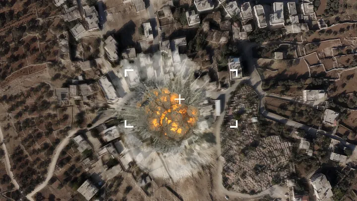
On May 13, 2023, Emanuel Fabian, a Times of Israel war correspondent, shared a video originally published by the Palestinian media agency ALRAY showing an airstrike near the Sheikh Salim Abu Muslim Mosque in Beit Lahiya.
Mosques can be used as orienteering sensors in Occupied Palestine to guide you to the exact coordinates of an incident. However, landmarks are more difficult to determine due to the poor quality of satellite imagery in Gaza, making it difficult to count back to the site of the airstrike. To create a wider overview of the area, it is now suggested to collect more footage of this moment.
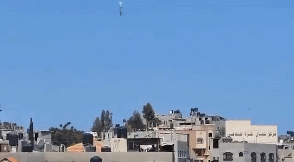
Another poster, Lance Dyer, also shared footage of the airstrike from a different angle. The video shows a building near a mosque with written text that appears to be leaning with a square or roundabout in front of it.
For a slight update to the satellite images to better view the structures and area, download the layers from Bing Maps via this website and import them into your desktop version of Google Earth Pro. This makes Gaza easier for you because Bing’s coverage is more relevant than Google’s.
By adding WikiMapia as a layer to Google Earth Pro, you can view descriptions and useful information about geographic features as you research and know you’re looking at Beit Lahia Roundabout, Beit Lahia Cemetery, Dr. Saud Romia Dental Clinic, Al-Sheikh Saad Mosque and Sheikh Salim Abu Muslim Mosque.
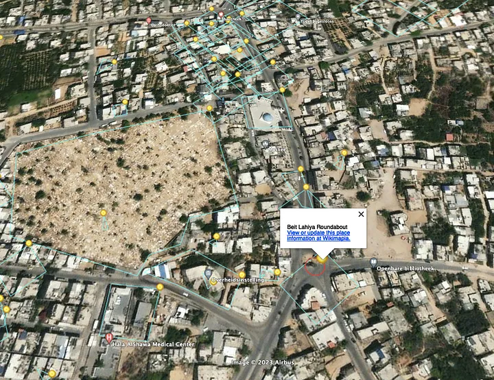
By comparing geographic objects with video footage, we can say with confidence that the airstrike was carried out at the following coordinates: 31.54803761602032, 34.49995848939983.
The aftermath of an airstrike is usually covered by the Israeli or Palestinian media. This allows you to look further to see if it was an accurate geolocation or if it was closer to the target.
“At approximately 10:05 a.m. the same day, Israeli warplanes fired two rockets at the three-story house of Faraj Fathi Banat, 39, near the Beit Lahiya roundabout (North Gaza District). Three families of 22 people lived in the house, including 12 children and four women. The attack left two women with minor injuries and completely destroyed the house. Neighboring houses and the Shih Saad Mosque suffered material damage. Israeli forces called one of the residents of the house to inform him of the intention to strike the house.”
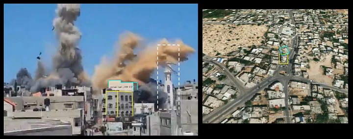
“The IDF confirms the attack and killing of Islamic Jihad operations chief Iyad al-Hassani.” Emmanuel Fabian reported on May 12, 2023. “He is the sixth high-ranking Islamic Jihad member killed by Israel since Tuesday.” Along with the news, a video of the strike, published by the Israel Defense Forces, appeared.
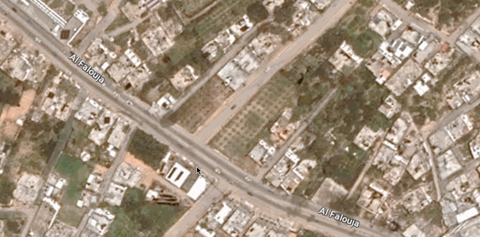
The video shows the impressive building al-Hassani was in, but it doesn’t reveal much of the area so we can narrow down our search. Aurora Intel also shared a recording made by a Palestinian citizen of Gaza City that shows more details of where it happened: Al-Nasr Street. We knew it was the same airstrike because the buildings matched those seen in the footage released by the IDF.
To find Al-Nasr Street or Hai al-Nasr in Gaza City, you need to visit Wikipedia and access GeoHack Toolforge, which will take you there. While this won’t immediately lead you to the location of the airstrike, it will give you a starting point.
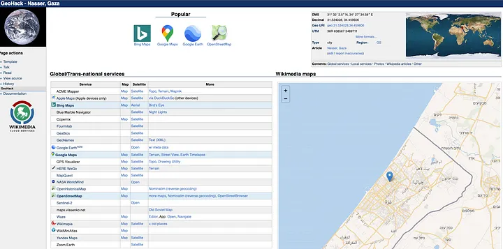
Al Nasser, as it is called on Google Maps, is a long street, but the geographic features shown in the video are quite clear and can be picked out as you scroll down the road.
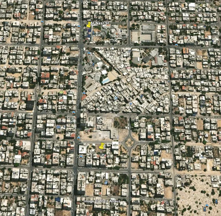
Heading down one of the streets to the east, we flipped the view in Google Earth Pro based on the visuals and were able to map the location, including the airstrike target, to 31.530278, 34.456250.
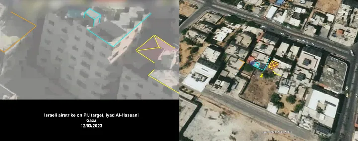
Meanwhile, Israeli warplanes fired a rocket at an apartment on the fifth floor of the six-story Banyas building in the Al-Nasr neighborhood of western Gaza City, killing Islamic Jihad leader Iyad al-Hasani, 51. and 33-year-old Mohammed Walid Abdelal, injuring others, including two children. The attack caused material damage to some of the neighboring apartments.
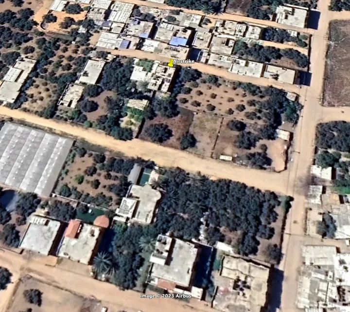
On May 13, 2023, the Israel Defense Forces tweeted footage of an airstrike on Palestinian Islamic Jihad member Muhammad Abu Al-Ata. At the same time, Intel Doge described it as happening in the eastern part of the Shejaiya district in Gaza.
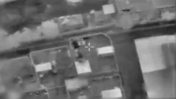
After first moving into the Shejaya area with GeoHack Toolforge, we started placing pins at intersections as a method of excluding what is no longer relevant when exploring geolocation. That way, you end up with the most potential just for further pinpointing.
Thus, it is known that the airstrike on Muhammad Abu al-Ata’s apartment took place at the following coordinates: 31.497056, 34.473500.
“At approximately 1:30 a.m. on Saturday, May 13, 2023, Israeli warplanes fired four rockets at the three-story house of Salim Hassan Abu al-Ata, 60, on Al-Tawahin Street, east of Al-Shujaya neighborhood, east of Gaza City. Two families of 20 people lived in the house, including 13 children and two women. The attack caused significant damage to the second and third floors and caused material damage to neighboring houses. Israeli forces called the owner of the house to inform him of the intention to strike him.”
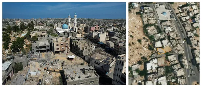
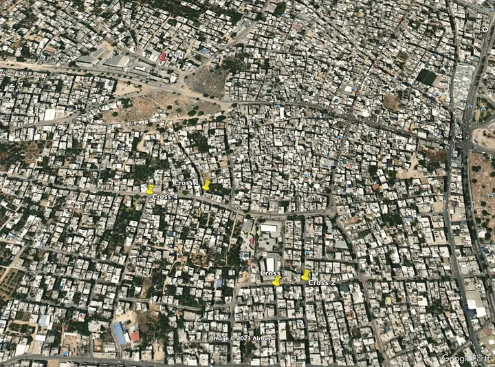
Nour Odeh posted on May 13, 2023: This airstrike destroyed an entire residential building in the Al-Zaytoun neighborhood of Gaza City. An additional report said it was near “Cosho Street” and although it wasn’t the place we were looking for, it eventually led us to the right place.
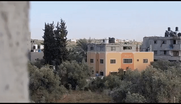
After first discovering that several airstrikes had taken place near the Salah Al-Din Mosque (31.497234945614753, 34.4579431571057), we searched for additional images in the press or on stock photography websites. Only to find the next photo via agefotostock.com:
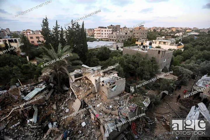
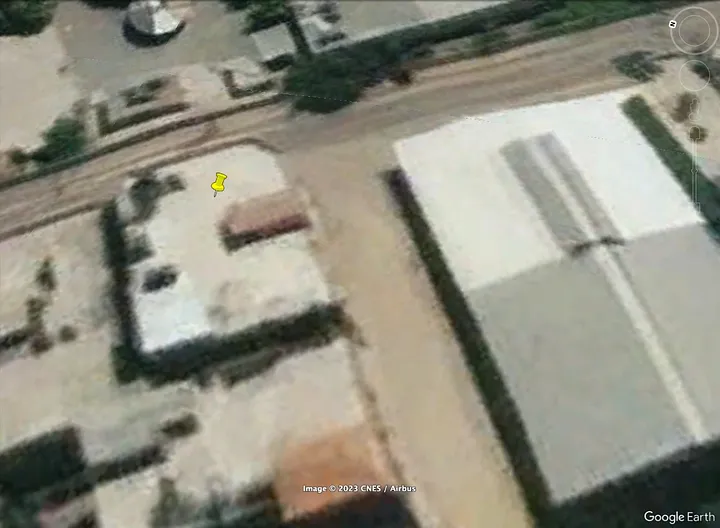
The image suggests it is in the Al Zeytoun area, an area with nearby agricultural activity, as you can see behind the greenhouse behind. Moving further south/west (southwest) from the Salah Al Din Mosque, we were able to find the location of a house that was razed to the ground by an Israeli airstrike at coordinates 31.485750, 34.456333.
During our geospatial investigation of these airstrikes, we came across a moment where we zoomed in on Google Earth Pro and Google Maps. What happened was that the satellite images began to change from the usual terrible quality to better quality at deep zoom.
It later remained during the downscaling, but showed that parts of the Gaza Strip, such as Beit Lahiya, had been upgraded since April 22, 2022, while Gaza City remained bad, as shown in the following screenshot:
Maybe Google has finally decided to update the image, but not completely yet. Hope you enjoyed this blog entry and learned about our methodologies used to apply geospatial research in the Gaza Strip.