28.04.2025
27 min
1182

Further development of the capabilities of unmanned aerial systems requires not only a deep understanding of the tactics of use, but also a clear organization of communications, technical operation and mission planning. The peculiarities of work in maritime operations, the nuances of servicing UAVs and batteries, as well as the influence of weather factors determine the overall effectiveness of task performance. The correct use of concise communication codes and real-time interaction procedures is key to successful coordination of forces. In this part of the article, we will consider practical aspects of ensuring the safety, operation and planning of UAV missions based on real combat experience.
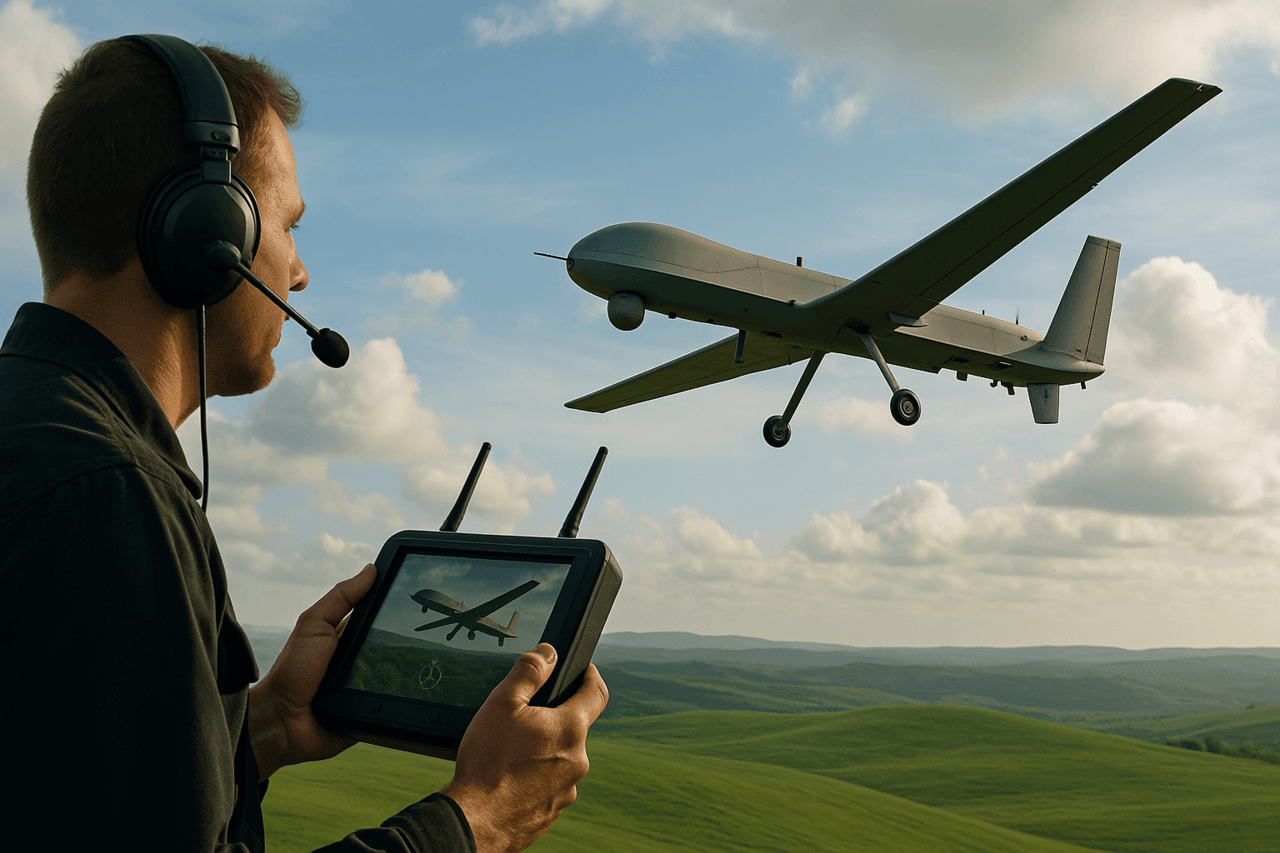
Ensuring reliable communication with UAVs is one of the key elements when using UAVs in combat conditions. It is communication that determines the capabilities of controlling the flight of the device, the operation of its target load and the transmission of intelligence information. UAV operators must be informed in advance about possible enemy actions and the influence of environmental factors that can reduce the quality or interrupt communication with the UAV.
Despite the fact that data transmission from UAVs is usually carried out in almost real time, there are factors that can cause significant delays. In particular, each repeater on the signal path adds about 0.5 seconds of delay, and after passing through several such stations, the total delay can reach several seconds. This can create a gap between the actual actions of the UAV and the data received by the end intelligence consumer.
UAV operators should pay special attention to frequency management. Before performing tasks, they must receive comprehensive information from liaison officers about the conditions in their area of joint operations. The mandatory issues to be familiarized with include:
frequency coordination and airspace conflict prevention measures, including the location of active jamming sources (both homemade and industrial);
methods of communication and cooperation used in the joint operations area;
procedures for access to joint forces and assets;
frequency and communication allocation maps for the area of operations;
contact details of persons responsible for organizing communications.
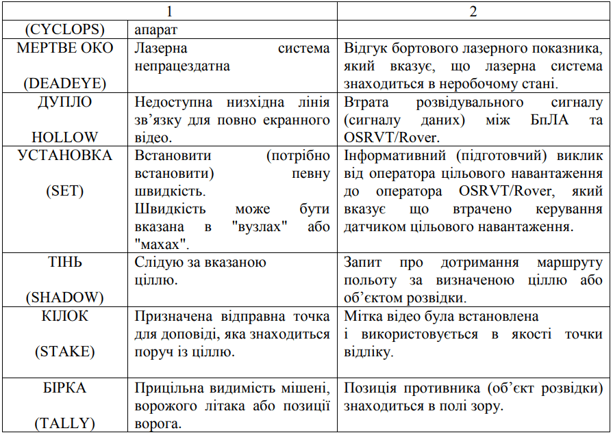
For effective coordination of the actions of units during operations, short communication codes are widely used. In the field of UAV application, such a system is not yet fully standardized, therefore, before each task, UAV crews should agree on negotiation tables with coded phrases in advance. It is with the help of these phrases that commands and reports will be transmitted via communication means.
To prevent the enemy from intercepting and decoding information, these coded tables should be changed regularly. When planning tasks, it is advisable to use already developed aviation short codes, especially those that are successfully used during joint exercises with NATO units.
Some of the most common and important codes for use by UAV crews are given in Table 4.
Preparation for the implementation of tasks is a mandatory stage for all types of operations, but for special operations it becomes especially critical due to the increased level of complexity and risk. Repeated practice of individual stages of the operation during preparation is vital. This is due to the fact that the numerical composition of the group and the nature of the tasks can vary from mission to mission, and the consequences of the implementation of tasks have a potential strategic impact.
Special operations are distinguished by the fact that specialists from different units are involved in their implementation, who are often working together for the first time. In addition, individual tasks, on which the success of the entire mission depends, cannot always be performed simultaneously or integrated according to a pre-established scheme.
During the preparation process, weaknesses in the operation plan are identified, alternative options for its implementation are worked out, and measures are developed to respond to possible emergency situations in the field.
UAVs as part of the SSO perform specific tasks, including:
surveillance of areas of responsibility when organizing resistance movements, sabotage and counter-sabotage measures;
performing tasks within the framework of information and psychological operations.
The successful use of UAVs is impossible without careful security of all aspects of the operation: operational, communication and physical. Control over the leakage of critical information must be carried out from the planning stage until the moment of the return of forces after the operation. Violation of security measures can lead to the disclosure of plans to the enemy and disrupt the mission.
To make the most effective use of the potential of UAVs in maritime operations, comprehensive planning must be carried out before their arrival in the mission area. The planning process should include:
analysis of the expected operational environment;
determination of the composition of the support forces;
establishment of the order of command of the naval and air components;
development of communication methods for direct and indirect control of forces and assets, including air vehicles and UAV payload missions.
Planning must consider all possible scenarios: anti-submarine warfare, surface warfare, theater air operations, mine warfare, counterterrorism, strike missions, special operations, offensive information campaigns, and naval fire support.
National airspace extends 12 nautical miles from the coastline of the country concerned, including all its islands or groups of islands.
Regarding international straits, military aircraft have the right to transit through international waters, but when passing through the strait they are obliged to comply with the rules of the airspace without delay and to avoid any aggressive actions towards coastal states.
Figure 15 illustrates the division of oceanic spaces and air zones in accordance with the provisions of the 1982 United Nations Convention on the Law of the Sea.
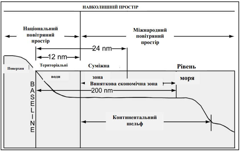
Note: Under international law, the sea and the airspace above it are generally considered neutral territory. Therefore, the nature of maritime operations is significantly different from that of operations on land. At the same time, different states may interpret international law differently, ranging from minor differences to major differences in the approaches of allies, partners, or adversaries.
Naval commanders must be fully informed about national interpretations of international law and be aware of how these differences may affect the course and outcome of planned operations.
Weather factors can significantly complicate the use of UAVs in maritime operations. Adverse weather phenomena affect the search and recognition of targets, orientation in space and subsequent decoding of collected intelligence information.
The main weather limitations affecting the operation of UAVs in the maritime component are systematized in Table 5.
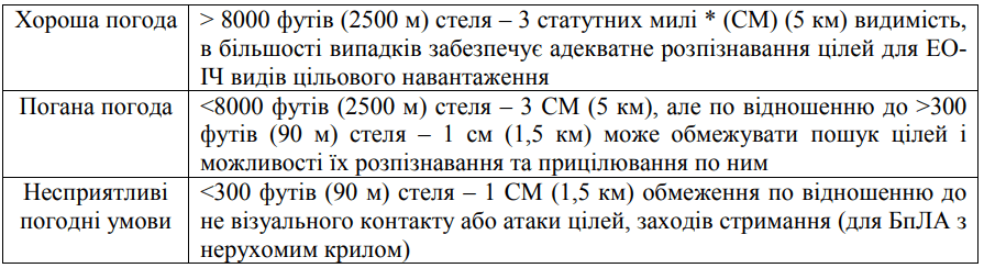
* statute mile – a unit of length used in England and the United States to measure long distances on land.
Wind – Strong surface winds can generate rough seas and make it difficult to detect surface targets at low altitudes. Sea spray and the presence of sea salt in them can reduce (negate) the ability to use electro-optical, infrared target loads when conducting reconnaissance at low altitudes.
Sea surface conditions – A ship in rough seas can rise vertically by as much as 30 feet (10 m) or more in addition to the rolling effect. This can significantly affect the process of launching and returning to the deck of a UAV. Reduced angle of attack and movement (shift) of the laser beam are potential factors that must be considered.
Water temperature – radical changes in water temperature (shallow versus deep water, Gulf Stream, etc.) will affect thermal imaging systems.

Technical operation of Class I unmanned aerial systems of state aviation of Ukraine is carried out in accordance with the requirements of the Order of the Ministry of Defense of Ukraine dated August 10, 2018 No. 401. This document establishes clear rules for the organization and conduct of all work related to the operation of Class I UAVs.
Compliance with these rules is mandatory for all subjects of aviation activity of state aviation that have units operating UAVs.
UAV batteries are operated by crews and technical personnel of support units in full compliance with the battery manufacturer’s instructions, the requirements of the UAV operational documentation and orders of the higher command.
Responsibility for organizing the operation of batteries lies with the senior engineer or head of the unit’s engineering and aviation service.
On-board batteries are assigned to a specific UAV. The use of a battery from another vehicle is possible only by decision of the senior engineer with a mandatory entry in the appropriate log.
It is FORBIDDEN to leave batteries on the UPS in the following cases:
when detecting malfunctions or failures;
during storage of the UAV;
during prolonged exposure of the UAV at temperatures below zero, unless otherwise specified in the instructions.
The number of charged battery packs is determined to ensure continuous performance of tasks with maximum load.
IMPORTANT! The battery charging cycles are recorded by the BPA aviation technician.
Before installing the battery, the charge level must be checked. After the flight, the residual charge is recorded with a marker on a special sticker. All batteries must have individual numbers to control uniform use.
The UAV is the operator’s combat weapon. Therefore, the complex must be treated as such – as a weapon that must always be in a state of full readiness.
UAV training begins immediately after the flights are completed.
First of all, the following are charged:
First of all, the following are charged: laptop and antenna batteries;
batteries for powering the UAV engines.
Only after the batteries are fully charged is the flight considered complete.
Special attention should be paid to PD batteries. When using metal hydride batteries, over-charging can damage them.

While charging is in progress, the crew conducts:
cleaning surfaces and screws;
inspecting the device for cracks, damage, abrasions;
checking the integrity of the camera optics and structural elements;
servicing the instrument.
Key requirements:
Laptops are used exclusively for combat missions.
Downloading third-party programs is strictly prohibited.
The UAV tool is used only for its intended purpose.
Preparation of equipment for morning flights begins in the evening!
When assembling a UAV, it is necessary to:
follow the “three-finger rule” – nylon screws are tightened easily, without excessive force, to avoid stripping the threads;
maintain cleanliness and order – all tools must be stored in designated places;
it is forbidden to keep tools in pockets;
cases and bags are placed compactly near the assembly site.

The effectiveness of aerial reconnaissance directly depends on the systematic approach. This means that reconnaissance should be carried out systematically, with constant study of the territory within the operational zone of the relevant unit. First of all, clear boundaries of the space to be investigated are determined.
The first stage is a high-altitude flight over the area of interest (or area of responsibility). The flight altitude is set to the maximum possible for this type of target load, which is installed on board the UAV.
The main task at this stage:
Identify enemy strongpoints and fortifications;
Identify established movement routes;
Identify potential locations for manpower, weapons, and equipment;
Record troop concentrations, pontoon crossings, and refueling stations;
Identify cover for equipment and covered firing positions;
Assess possible enemy evacuation routes or directions of possible attacks and counterattacks.
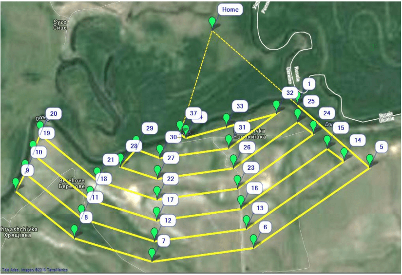
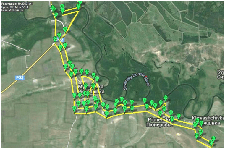
When constructing routes for detecting targets during a reconnaissance flight, the principle applies: the UAV must first reach the farthest border of the reconnaissance zone, and then gradually approach the landing point.
Such route construction ensures a safer return of the device and resembles the work of a shuttle on a loom – gradual “stitching” of the territory from the far to the near border (Figure D2.1).
After decoding the received data and determining the priority targets, UAV flight routes are developed exclusively over important places. Such a flight is carried out at an appropriately low altitude in order to obtain the most clear and informative image of the targets (Fig. D2.2). The route is developed in the form of a closed curve.
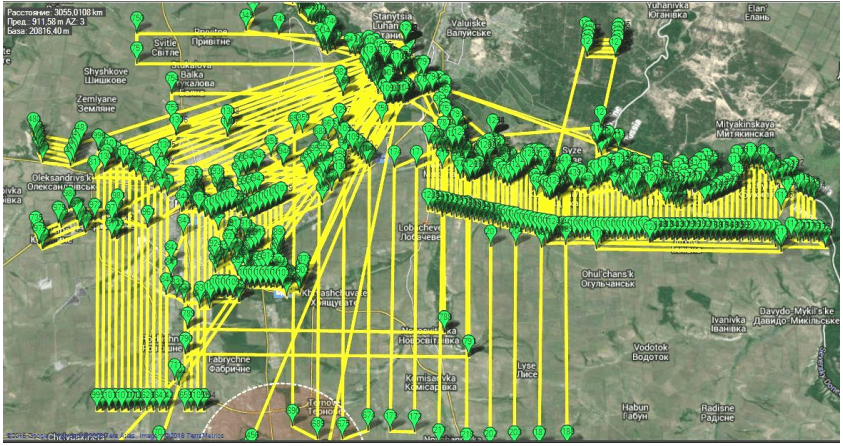
When planning a series of flights, the coverage of the territory by routes is monitored (Figure D2.3).
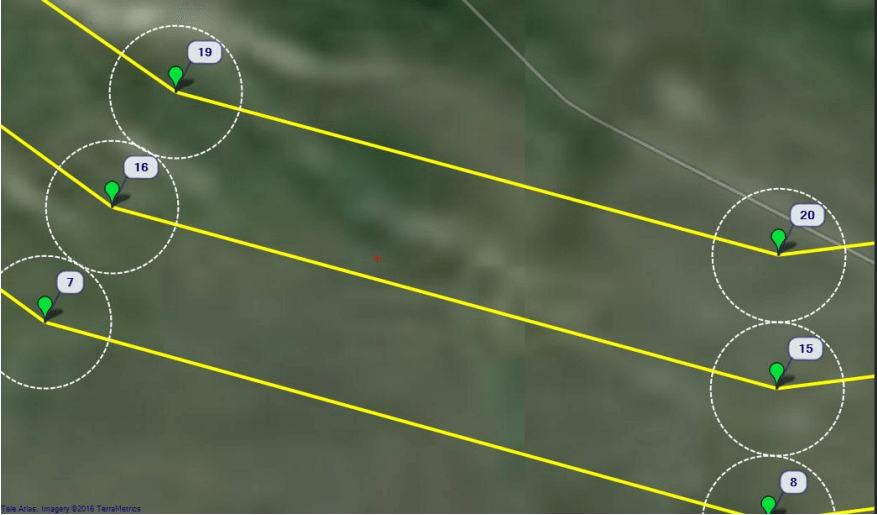
Routes are developed taking into account the camera’s range. For convenience, the program indicates the shooting range with a dotted line (Figure D2.4).
The altitude of the UAV flight must be adjusted according to the terrain features. In the reconnaissance area, it is necessary to carefully study the presence of natural lowlands, riverbeds, gullies, and also determine the location of elevations – hills, ridges, embankments, dams, and waste heaps.
The altitude of the terrain is checked directly during route preparation, using the altitude viewing function in the upper right corner of the tablet or laptop screen when hovering the cursor over the corresponding areas of the electronic map.
UAV flight routes should be designed with particular care. Excessive overlap of survey areas leads to:
prolonging the UAV’s stay in enemy territory;
duplication of intelligence materials without practical benefit;
unjustified increase in the number of sorties and data processing time.
During the flight, there may be a need to clarify the situation. In such cases, the operator turns on streaming video on certain sections of the route or forcibly takes photos of the most interesting objects.
Without proper processing and organization of intelligence data:
it is difficult to analyze changes in enemy fortifications;
it is difficult to track the accumulation of forces for possible attacks or raids;
it becomes impossible to timely detect signs of enemy regrouping.
Therefore, data collection and systematization are mandatory and should be carried out with the utmost responsibility.
After the return of the UAV:
Photo and video materials are immediately copied from the devices to the computer.
Memory cards must be formatted to avoid possible leakage of intelligence information in the event of loss of the UAV.
It is strictly forbidden to save files in folders like “New Folder 2”!
Instead, you should:
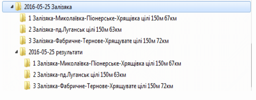
create a folder with the flight date and a conditional name of the start location (for example: 2016-05-25 Zalizyaka);
inside this folder create separate subfolders for each flight route: 1 Zalizyaka-Mykolaivka-Pionerske-Khryaschivka targets 150 m 67 km; 2 Zalizyaka-south Luhansk targets 150 m 63 km;3 Zalizyaka-Fabrichne-Ternove-Khryaschuvate targets 150 m 72 km
Flight logs and all received photographic materials (primary sources) are uploaded to these subfolders.
After decrypting the data:
another main folder is created – for example, 2016-05-25 results;
in it – similar subfolders for each route, but only frames with detected targets are saved.
The directory structure looks like in Figure D2.5.
Decryption. While one external pilot (operator) is landing the UAV, disassembling the device to replace the battery, and loading the data, another operator simultaneously creates a corresponding folder named by the date and place of the flight, as well as a subfolder for the route, and receives a flight route track. Thanks to this, at the time of copying the photos, the entire necessary directory structure is ready for organizing the materials.
If the task was urgent and the goals were defined in advance, the crew immediately begins processing the data. If the task was planned, the crew continues flying according to the schedule.
After completing all the flights, the crew returns to the base, puts the batteries on charge, and, if necessary, changes equipment before starting the decryption.
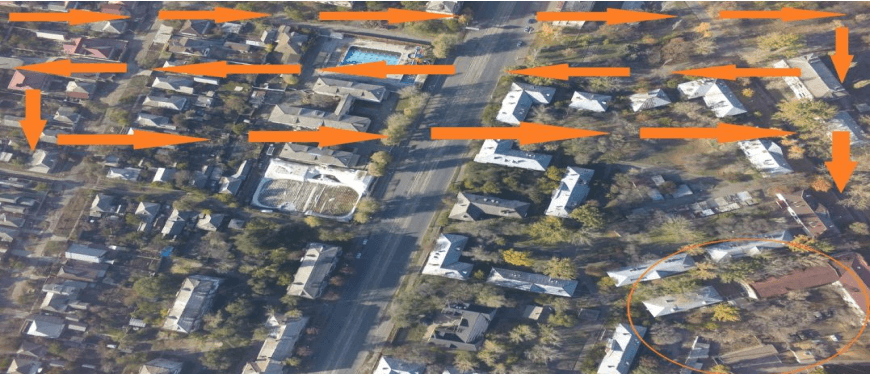
In the decryption process, all the photos are first viewed in the order in which they were received. Landings, villages, and city blocks are viewed very carefully, with the maximum possible zoom in to achieve the best detail in each picture.
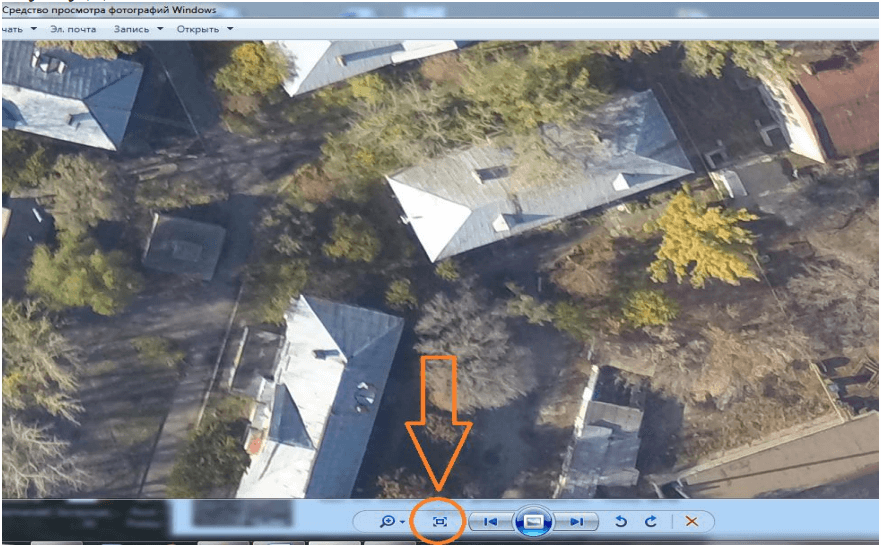
If a standard image viewer is used, zooming is done via a special button (an example of which is shown in Figure D2.6).
Quarters and village yards should be inspected yard by yard. This should be done systematically, similar to the work of a weaver’s shuttle, as shown in Figures D2.7 and D2.8.
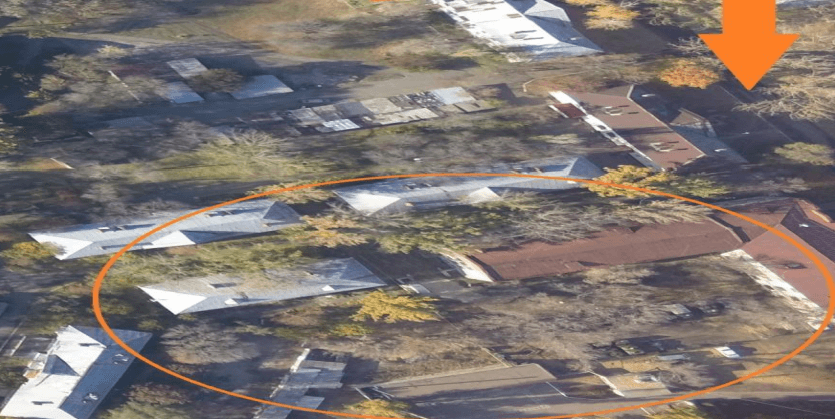
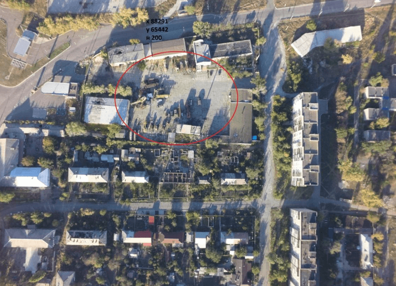
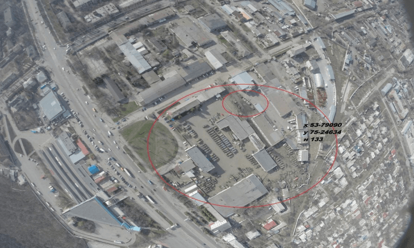
Identifying different types of equipment in the images helps determine the purpose of individual buildings or complexes. For example, the presence of command and staff equipment, cars, and security vehicles may indicate that we are looking at a headquarters or control point.
Sometimes in a photo, certain objects may look like equipment, although in reality they are buildings in yards. In such cases, you need to think: could this “equipment” really have entered or left this place? Clues include traces of transport, paths, broken branches, traces of garbage or smoke – all this can indicate the presence of camouflaged equipment, dugouts or manpower, or, conversely, confirm their absence.
Sometimes there are accumulations of equipment that seem suspicious: there are no tracks, there are no traces of the presence of troops, and tank barrels of different lengths – all this suggests that the photo may contain mock equipment.
Military areas usually have characteristic features: a fence, trenches along the perimeter, a neat area without scattered debris and some camouflage.
A company was discovered without obvious military equipment, but trenches were observed at the corners of its fence. Concrete panels were being loaded onto trucks on the territory. Further observation of the truck route revealed the construction of covered positions for rocket artillery in the field. Thus, a series of questions, assumptions and observations led to the disclosure of an important military facility.
This case emphasizes: one cannot consider individual photos without analyzing the full picture and related information. Regular discussion of flight results within the camera team is mandatory.
Photos containing important objects are copied and renamed. Before the factory name of the photo (for example, “GOPR0001”), add the target number: 1 GOPR3021, 2 GOPR3048, 3 GOPR3110. The original names are left to facilitate searching in the base folders.
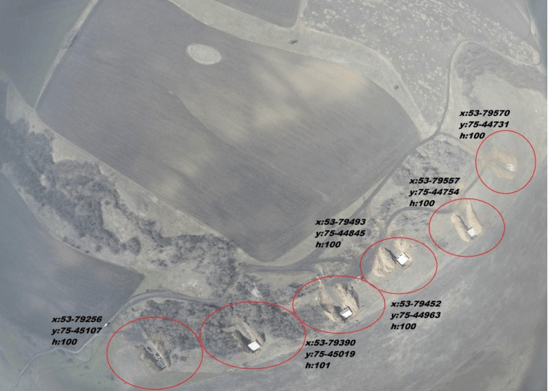
Objects in the photo are marked with circles, segments or rectangles and their coordinates are indicated in the SK-42 system. For a single target, its coordinates are indicated. The “Paint” program is used to enter these marks.
If the objects have a separate meaning, each is marked individually. Industrial zones or enterprises with equipment are marked with coordinates in the center of the territory.
Defensive lines are marked differently: Trenches lines – along the edges, caponiers – separately, dugouts and accumulations of equipment are also highlighted with separate signs.
Processing of intelligence reports after completion of aerial reconnaissance missions and assessment of detected objects may be limited by the intelligence and technical capabilities of specific types of UAVs. Commanders should take these limitations into account and, depending on the situation, transmit the received data through special secure channels or standard intelligence reporting paths.
The effective use of unmanned aerial systems, based on the experience of conducting the Joint Operational Operations (formerly ATO), is based on a clear integration of planning procedures, technical training, communication organization and systematic processing of intelligence data. The success of operations using UAVs directly depends on the timely identification of weaknesses during training, coordinated work of crews, a deep understanding of the features of the terrain and the operational environment, as well as a high level of safety at all stages of task performance.
Careful management of communication frequencies, systematic updating of negotiation codes and constant readiness of the complex for operation determine the stability of operations in real time, even under enemy countermeasures. The organization of sea and air operations taking into account international law and weather conditions allows for the most effective use of UAV capabilities in a complex environment.
An important stage remains careful processing of intelligence information: timely downloading of materials, their systematization, careful decoding and correct identification of objects in the images. Making informed decisions is based not only on individual photos, but on a comprehensive analysis of the situation in the area of responsibility.
Overall, the use of UAVs in the combat zone has become one of the main tools for collecting intelligence, requiring high discipline, strict adherence to procedures, and a deep understanding of the tactical situation to achieve strategic goals.