28.04.2025
18 min
872

In modern conditions of combat operations, the role of unmanned aerial vehicles (UAVs) is rapidly growing. They are becoming an integral part of reconnaissance, fire coordination and ensuring the safety of operations. Understanding the basics of classification, technical capabilities and the influence of environmental factors on the effectiveness of UAVs is critically important for the formation of a successful strategy for their application. In-depth study of planning procedures, features of work in different weather conditions and on different terrain allows us to significantly increase the effectiveness of task performance. In this part of the article, we lay the foundation for further in-depth analysis, considering key theoretical aspects that are necessary for the successful use of UAVs in real combat operations.
The experience of using unmanned aerial vehicles (UAVs) during the Joint Operational Operations (formerly ATO) has demonstrated their high efficiency for units engaged in aerial reconnaissance, surveillance and reconnaissance, as well as tactical aviation support. Thanks to UAVs, units receive operational information in almost real time to perform reconnaissance, target detection, artillery fire correction and target designation tasks.
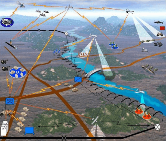
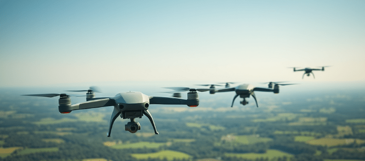
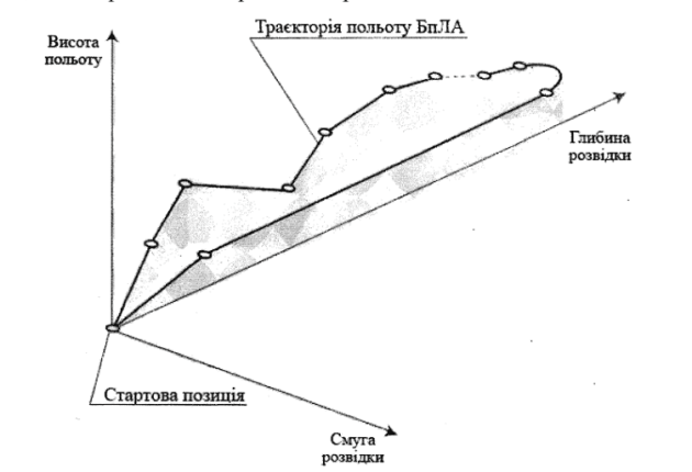
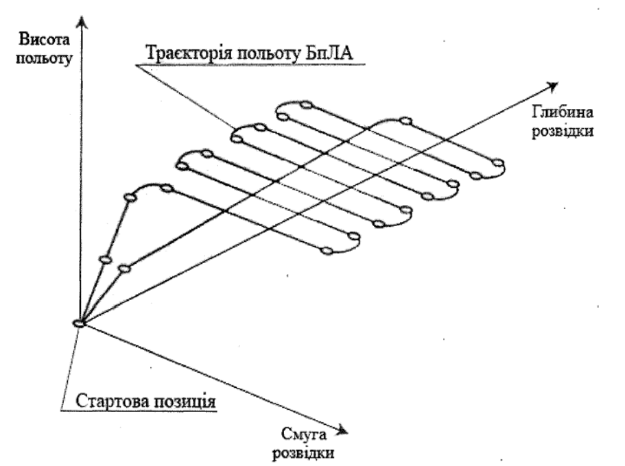
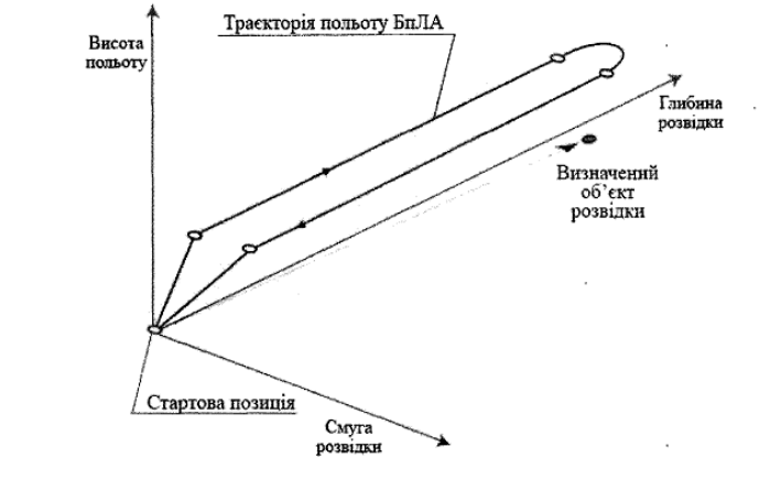
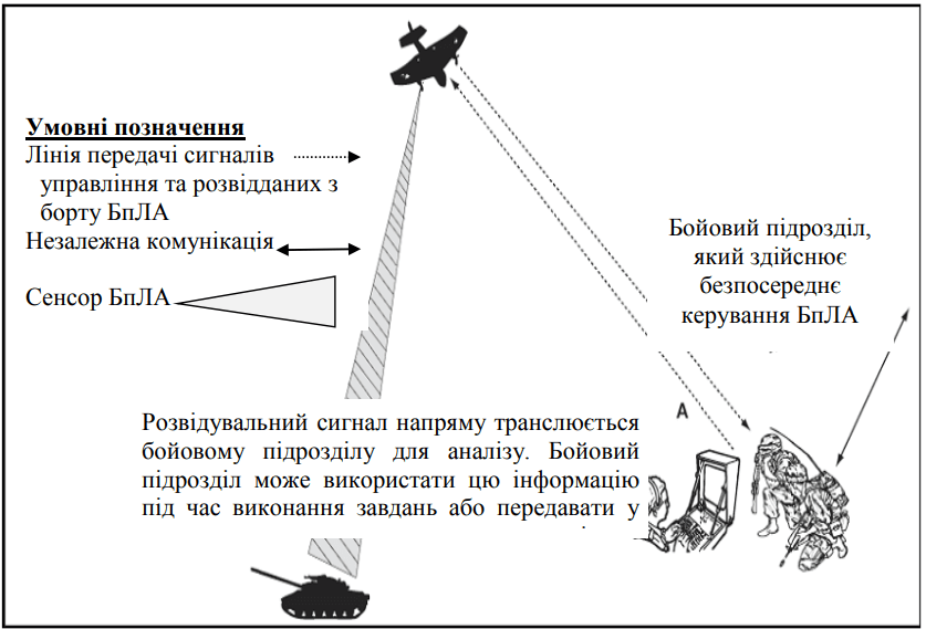
UAVs are capable of operating both in close proximity to the battle formations of their own troops and at a considerable distance – on the flanks or deep behind enemy lines (see Figure 1). They are equally effectively used in areas remote from the main fighting, for example, during anti-terrorist operations and the fight against insurgent formations.
The practice of the Joint Operational Operations has shown that the interaction of unmanned and manned aircraft significantly improves the quality of reconnaissance information and increases the accuracy of artillery strikes.
In addition, UAVs successfully perform the tasks of aerial reconnaissance of routes, planar and zonal reconnaissance, recording the results of combat operations on enemy targets, and can also work as repeaters of communication channels.
The integration of unmanned aerial vehicles into combat operations, along with the collective use of weapons, requires careful and complex planning, but is extremely important for increasing the effectiveness of operations.
A control point is a landmark clearly visible on the ground or on the screen of an electronic navigation device used to provide the necessary control over the movement of aircraft in flight. Such points are graphic control elements and act as control points in an air corridor, similar to control posts on ground routes.
An air corridor is a defined area of airspace that limits the flight path of aircraft near or below a specified altitude. It is created to ensure the safe movement of friendly forces and to avoid crossfire from own artillery when engaging aircraft.
A coordination level is a procedural tool for separating the movement of fixed-wing and rotorcraft by establishing a limit altitude below which only helicopters usually fly. This level is recorded in air traffic management plans with an indication of its status – mandatory or recommended. Any operations within this level must be coordinated with the appropriate airspace coordination bodies.
A box is a three-dimensional diagram used to coordinate air fire support. It helps accelerate the attack of targets on the ground and can be supplemented by ground-based fire systems using indirect guidance.
Restricted operating areas (areas) are specially designated areas of airspace of certain sizes, created to perform specific tasks, for example, for launching or landing UAVs. Such areas are formed as needed in accordance with the operating conditions of one or more users within the restricted airspace.
Operation of UAVs is a stage of the life cycle of an unmanned aerial vehicle complex, which begins from the moment the product is accepted by the operator and continues until it is decommissioned.
Malfunction is a condition in which the object loses the ability to perform at least one of its intended functions.
Damage is an event that leads to a violation of the serviceability of an object, but the object remains operational.
Storage of an unmanned aerial vehicle during operation is the presence of an unmanned aerial vehicle in a specially designated place in a specified technical condition to ensure its preservation for a specified period.
A complaint is a written statement by a consumer to the supplier (manufacturer or repair company) about defects in products or work discovered within the warranty period. It contains a requirement to restore the product to its operational condition, replace it, or re-perform work in accordance with established standards.
The composition of unmanned aerial systems is formed depending on their classification and technical characteristics. The main components of an unmanned aerial system include:
communication systems with air traffic control authorities and surveillance means, including voice radio communication, data exchange channels between the flight controller and the external operator, automatic dependent surveillance systems, secondary surveillance radars, etc.;
navigation equipment for orientation during the flight;
technical means that ensure the takeoff and landing of the drone (depending on the specific takeoff and landing technology);
flight control computing complexes, automatic control systems and autopilots;
equipment for monitoring the technical condition of the UAV during operation;
emergency flight termination systems that allow for the safe completion of the flight in the event of a critical situation;
equipment for the automatic return of the drone to the launch site in the event of loss of communication or control;
weapons and specialized equipment for performing combat or special tasks, such as the use of aerial weapons, reconnaissance, target designation, electronic warfare, and monitoring of objects and territories.
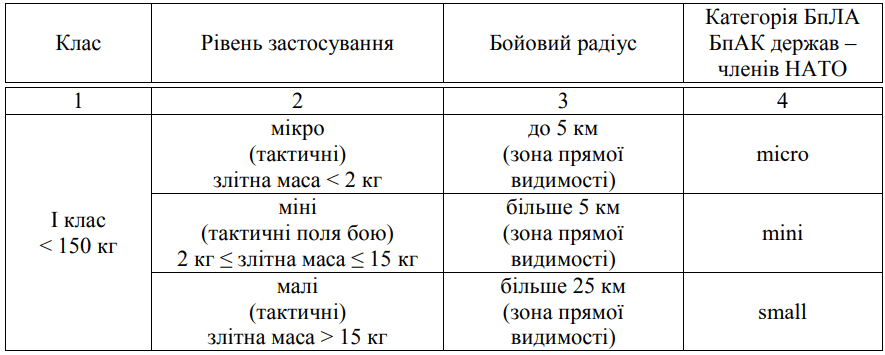
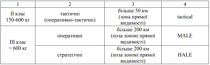
The classification of unmanned aerial vehicles in the UAV system according to their main characteristics is presented in Table 1.
UAVs (except autonomous ones) are piloted from remote piloting points using a command and control line. During the flight, the UAV is controlled from one or more remote control stations (but in no case simultaneously). The remote control station is a portable device or a multi-controller (single-controller) station, can be located indoors or outdoors and can be stationary or mobile (mounted on a vehicle / ship / aircraft or portable). Access to the remote control station by unauthorized persons is prohibited.
The command and control line is simplex or duplex, it is used in direct line of sight (LOS) or beyond line of sight (BLOS):
LOS – the transmitter and receiver are within the range of mutual radio link and communicate directly or via a ground network, provided that the remote transmitter is within LOS of the UAV;
BLOS – any configuration in which the transmitter and receiver are not within LOS. The concept of BLOS covers any systems (ground, air, satellite) in which the RPAS communicates with one or more RPAS.
Manual control (Category A, BLOS). This type of control involves manual control of the UAV using the handle, rudder pedals and engine control lever, as well as the use of the autopilot to maintain a given flight mode. Manual control of Category A is considered the most complex form of flight control by an external operator.
Control via autopilot (Category B, BLOS). Control in Category B is carried out using the autopilot with the ability to manually adjust the parameters of speed, altitude, heading and vertical speed. The system provides control flexibility through the autopilot interface and allows the transmission of emergency commands.
Route control via points (Category C, BLOS). In this variant, the operator exercises only limited control over the UAV, changing the route by adding or removing waypoints from a pre-planned flight. This mode gives the operator more time to analyze the situation and adjust flight parameters.
Control of the UAV in line of sight (LOS) mode during takeoff and landing with subsequent transfer of control to BLOS. To maintain visual contact with the UAV during takeoff or landing in line of sight mode, an additional operator is involved. After switching to BLOS flight, control is transferred to another RPAS, which may be different from the original one.
Approaches to planning the use of UAVs are similar to methods of planning operations of ground units and are close to the procedures for using manned aircraft.
Intelligence headquarters servicemen contribute to the effective exchange of information between units using UAVs and supporting units, while ensuring an understanding of the capabilities and limitations of UAVs.
UAVs are capable of simultaneously performing several tasks thanks to a wide range of target equipment and combat modules.
Each UAV flight is planned taking into account the size of the device, its flight altitude, speed, nature of the mission and the rules for using airspace.
Different crews can work at different stages of the flight – for example, a separate team for takeoff and landing and another for reconnaissance.
All crew members must clearly understand the task, goals and sequence of actions. Planning is coordinated so that each person fully understands the stages of the task and the elements of airspace management.
UAV flights in peaceful territory are carried out in accordance with the Rules for the performance of flights by unmanned aircraft complexes of the state aviation of Ukraine (Order of the Ministry of Defense No. 661 dated 08.12.2016).
Combat UAV flights are planned in accordance with the Temporary Instruction on the Combat Use of Class I UAVs in the Armed Forces of Ukraine (Order of the General Staff of the Armed Forces of Ukraine No. 228DSK dated 18.06.2018).
Key information for the commander before the mission:
UAV starting point, start of reconnaissance, planned route and end point of the mission;
pre-defined critical points;
reconnaissance preparation measures;
restrictions or complications on the route;
weather conditions;
characteristics of units or vehicles on the route, time of day;
potential threats to detection.
Tasks performed by the BpAK
BPAs provide:
operational aerial reconnaissance;
continuous surveillance of territories;
providing commanders with up-to-date information on the combat situation;
increasing the security of the main forces;
detecting, highlighting and assessing targets;
ensuring communications through data relay;
supporting troop movements and identifying threats;
supporting search and rescue operations.
The type of UAV is selected depending on the nature of the tasks.
Factors to consider when planning:
tactical and technical characteristics and limitations of UAVs;
terrain features;
weather conditions;
target load capabilities;
enemy air defense and electronic warfare capabilities.
Restrictions on use in different weather conditions are specified in the operating instructions for each UAV. The final decision on the flight is made by the crew commander.
The shape and nature of the terrain have a critical impact on the effectiveness of reconnaissance equipment and command and control systems (C2).
Artificial objects such as cities, bridges or communication lines can reduce the effectiveness of reconnaissance and data transmission.
The best conditions for the operation of UAVs are created by open terrain (steppe, desert), while mountainous and forested areas significantly complicate the use of surveillance systems and require special measures, such as the use of satellite communications or multi-channel control systems.
Weather conditions must meet minimum standards for safe mission performance. In some cases, the command may adjust these requirements depending on the importance of the mission.
Table 2 identifies the main weather restrictions that affect UAV flights. Tactical UAVs are particularly sensitive to weather factors. Some UAV models are also capable of independently determining meteorological parameters such as wind direction and speed, temperature and pressure (if equipped with appropriate sensors).
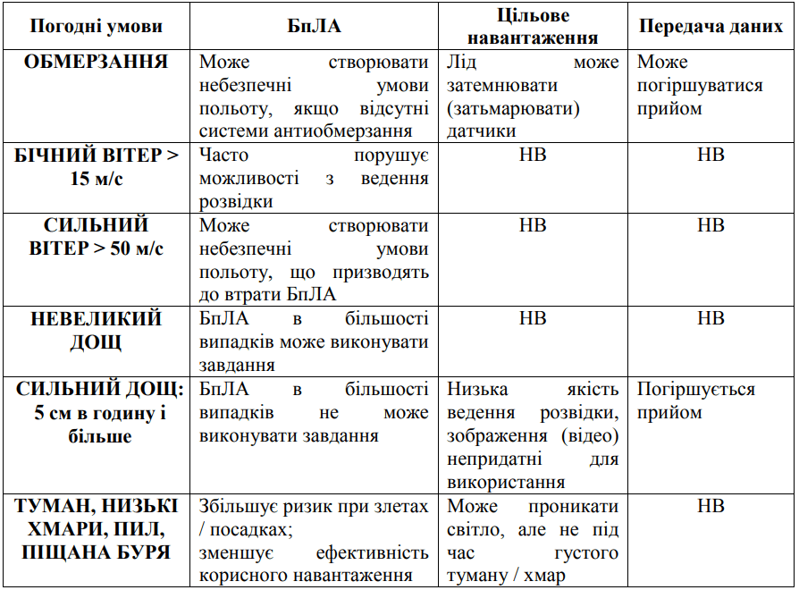
Precipitation, wind, and temperature can all negatively affect the performance of an UAV and its systems. It is especially important to consider the reduction in flight altitude under icing conditions, which occurs at temperatures below 0°C in the presence of visible moisture.
Fog and low cloud cover generally reduce the effectiveness of the target payload and significantly complicate the landing of the aircraft. Infrared (IR) cameras can partially penetrate light fog, but in dense fog or thick clouds their effectiveness is significantly reduced. In such cases, it is often necessary to fly at low altitudes to obtain intelligence data suitable for decoding.
Field measurements of weather conditions are allowed to be carried out using mobile or hand-held meteorological stations. The Central Military District, individual branches of the Armed Forces of Ukraine, and the Ukrainian Air Force, which have UAV units, determine critical weather conditions under which flights of certain classes and types of UAVs are limited or terminated. These restrictions are set in accordance with the technical characteristics specified in the UAV CLE.
Permission to fly in specified weather conditions is granted by the commander of the unit where the UAV unit is located. The final decision to continue or terminate the flight during the mission is made by the external pilot (operator), assessing the actual and forecasted weather conditions.
When planning combat or special-purpose missions, the technical characteristics of the target payload are crucial for the success of the operation.
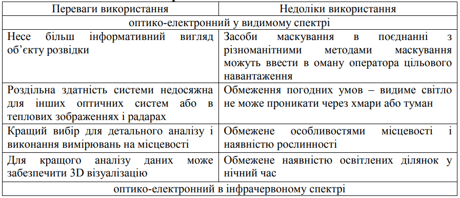
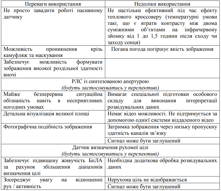
Currently, a wide range of target payloads are used for UAVs of various types, including optical-electronic systems in the visible range, infrared optical-electronic devices, synthetic aperture radars, and sensors for detecting moving targets.
The sensitivity of the reconnaissance equipment determines the quality of the data collected. The external pilot or operator must select the target payload that best meets the conditions for performing the aerial reconnaissance mission. The advantages and limitations of each type of target payload are described in detail in Table 3.
During the performance of tasks, UAVs usually avoid areas known in advance where enemy air defense, anti-aircraft artillery or electronic warfare systems are located. Although it is difficult to defeat UAVs with physical means, their flights are easily recorded by radio and radar reconnaissance means. Therefore, during the preliminary planning of flight tasks, it is necessary to take into account the choice of route points, flight altitude above sea level, entry and exit points from the reconnaissance or combat area, as well as current information about the presence of enemy air defense and electronic warfare means.
The assessment of threats to UAVs, both from ground-to-air and air-to-air means, must be carried out by planners. It is especially important to determine which of these threats are the most dangerous for the performance of a specific combat mission.
Responding to emergencies during a UAV flight is complicated by the dependence on the speed of control commands transmitted via communication channels or an Internet connection. Another limitation is that the operator receiving intelligence data for decryption cannot simultaneously control the UAV flight.
One of the main problems is the possibility of losing the data channel, which complicates the control of the device compared to traditional manned platforms. Therefore, special attention is paid to planning measures to prevent loss of communication, loss of positional data and ensuring emergency control restoration, taking into account the availability of the necessary communication resources.
In addition, an important factor in preventing emergencies is the ability of strike UAVs to restore communication by transferring control to another ground control point within line of sight (LOS). Such points must be compatible with the specific type of UAV and ensure the possibility of safe resumption of flight or landing.
UAV use can be considered similar to the use of manned aircraft from the point of view of the rules and principles of airspace operation. However, there are unique aspects that must be taken into account by commanders and planners when organizing UAV work.
Basically, support of tactical ground operations using UAVs is divided into two key categories: obtaining intelligence information (ISR) and supporting the actions of tactical aviation, missile forces and artillery. The features of the application are the specificity of the task, the presence of the enemy, terrain conditions, weather factors, the location of own forces, the level of support, time constraints and the impact of the presence of the civilian population.
The main principles of using UAVs are the correspondence of the tasks to the operation concept, focusing efforts on the most important areas and the correct allocation of resources. It is important to maintain constant readiness to perform tasks in any conditions, regardless of weather or time of day. High efficiency in collecting, processing and transmitting intelligence information is required.
Maximum use of all the capabilities of the UAV and its payload is also a mandatory element. Special attention should be paid to ensuring the survivability of the unit, which includes professional training of personnel and competent planning of flight routes to minimize risks. It is also critically important to ensure close interaction with other units – both during planning and directly during the execution of tasks. Cooperation with air defense, electronic warfare and manned aviation units must be clearly coordinated in time, space and by objectives.
The implementation of these principles is fixed in the form of algorithms that are worked out when planning tasks for specific units within their areas of responsibility.
To successfully perform ISR tasks, it is necessary to organize the complex work of all reconnaissance means: planning their application, using active sensors, processing the received data and distributing them within the reconnaissance system. The goal is to provide relevant intelligence support for both current and future operations.
UAVs are widely used to perform tactical aerial reconnaissance and surveillance as part of the ISR system. During operations, aerial reconnaissance allows you to collect information about enemy objects, their number, activity, location, affiliation to a certain type of troops and their weapons.
The most effective is to coordinate the work of UAV units with the actions of ground units. As a rule, traditional methods of conducting aerial reconnaissance are used, but depending on the situation and technical capabilities of the UAV, it is allowed to combine several methods within one flight.
The search for targets along a specified route is used in cases where there is primary information about their possible location or direction of movement, as well as in cases of favorable terrain, which allows you to unambiguously determine the position of targets.
This approach allows for the most effective use of the tactical and technical characteristics of the UAV and its equipment. The method is particularly effective for monitoring the front, flanks, rear, detecting threats on routes or during the assessment of road infrastructure. Additional tasks in this use are assessing road patency, selecting landing sites for aircraft, identifying dangerous areas or suspicious objects.
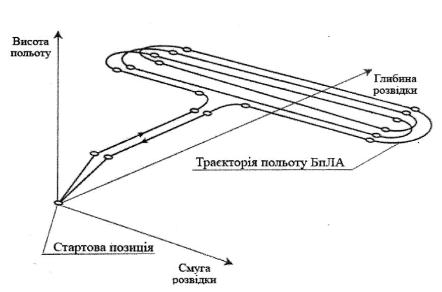
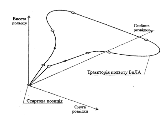
Search for objects (targets) in a specific area – used to detect group and single targets in the depths of the enemy’s battle formations (Figure 3).
For a detailed survey of individual areas of the terrain within the air reconnaissance area, straight parallel routes are used, taking into account the maximum width of the field of view of the target equipment (reconnaissance equipment) of the UAV at a given altitude of its flight.
The advantages of the method are the simplicity of planning reconnaissance, the presence of long sections of straight horizontal flight of the UAV, which makes it possible to obtain a higher-quality image of the reconnaissance area. However, the main disadvantage of this method is the low stealth of the UAV flight, especially with small capture strips of reconnaissance equipment.
As a rule, this method is used when existing information about the terrain is limited, the performance of combat missions continues with a change in the terrain, the boundaries of the performance of combat missions are limited, or if data on the situation on the enemy side are incomplete.
Searching for targets in a given area is often time-consuming, covers long distances, and requires special attention from the UAV crew. Planning guidelines are similar to the route reconnaissance procedure, except that it is necessary to consider the operation of multiple crews (manned and unmanned) on the same line.
Barrage in a designated area is the main method of conducting aerial reconnaissance by UAVs during observation of the situation in the depths of the enemy’s battle formations, during the performance of tasks of adjusting artillery and aviation fire and monitoring the results of fire damage (Figure 4). The main disadvantage of this method is the low stealth of the UAVs, the long duration of the flight in one area, which significantly increases the risks of hitting the UAV by air defense means.
Surveillance of a specific area – typically a target area or individual buildings located in areas of interest to the operational forces. The UAV can continuously send full-screen video to ground elements of a unified video surveillance system (Figure 5).
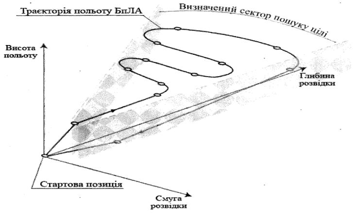
Search for objects (targets) in a specified sector – is used to detect moving (limitedly moving) objects in enemy territory using several UAVs, in cases where the location of enemy objects is unknown. When using this method, the enemy territory is divided into separate sectors relative to the location of the UAV deployment, in each of which a separate UAV performs the task (Figure 6). This method is highly effective in the absence of a continuous line of combat contact between troops.
Exit to a specific point on enemy territory and its circling (circling of an object) – is used when: engaging specific enemy objects at a given depth in their battle formations, performing tasks of adjusting artillery and aviation fire and monitoring the results of fire damage; conducting additional reconnaissance of enemy objects (Figure 7).
Flying around a defined line of enemy battle formations is the most effective method of conducting aerial reconnaissance, as it ensures stealth and low visibility of the UAV in flight, taking into account the speed, flight altitude, and short periods of UAV stay in one area (Figure 8). This method is used to reconnoiter the enemy and search for his vulnerable spots.
Long-term surveillance – provides continuous surveillance of roads (paths) on approaches or those bordering a defined area of interest, destination, and other critical areas (Figure 9).
To support the actions of the missile forces and artillery units, UAVs are involved in performing a number of important tasks. Among them: adjusting artillery fire during enemy engagement, detecting the front edge of defense and mine-explosive obstacles, determining the locations of enemy firepower, engineering structures and fortifications, clarifying the results of fire exposure and assessing the degree of damage to objects, as well as reconnaissance of targets and their coordinates during fire contact. In addition, UAVs can provide target illumination.
The use of UAVs in this direction requires a high level of coordination between the UAV crew and the artillery unit commander. Such interaction is possible only if the UAV operators have a good understanding of the specifics of artillery work, and the artillerymen have a good understanding of the capabilities and limitations of UAVs. The best results can be achieved through joint training during maneuvers and training firing.
The artillery commander must be aware that UAVs are the “eyes” of the battery, but they cannot instantly appear over the target. Therefore, before opening fire, it is necessary to coordinate the flight time of the UAV to the firing zone in advance so that at the moment of the start of firing the target is already within the range of the UAV reconnaissance sensors.
The remote piloting point of the UAV can be located next to the battery command post or be separately removed. In the case of established operational communication, the senior officer of the artillery unit can be at the PDP and directly control the process of fire adjustment.
An example of a problem situation may be the case when the UAV is sent to the target in advance, but the battery is not ready to open fire for technical reasons. The UAV, being over the target area, risks using up its batteries before firing begins. The presence of the device over the target can also warn the enemy about the preparation of artillery fire, which significantly reduces the effectiveness of the fire effect.
When adjusting fire, commands such as “undershoot” or “overshoot” are traditionally used, but modern software of some UAVs allows the operator to automatically determine its coordinates by clicking on the gap on the screen. Another option is to use an electronic map to link the gap to known landmarks without the need to know the exact position of their own battery. At the same time, it should be taken into account that UAVs usually cannot hover over the object and perform a flyby, which makes it difficult to accurately determine the direction of adjustment.
UAV operators must be well acquainted with the features of the terrain around the target and anticipate possible changes in the situation as a result of fire damage, in particular, enemy maneuvers towards other positions or an attempt to abandon the fortification. All possible scenarios must be discussed in advance at the planning stage together with the senior artillery officer and the UAV crew.
For further analysis and analysis of actions during a fire attack, it is recommended to activate streaming video recording on the PDP throughout the UAV flight.
The main task of the strike UAV is to detect and destroy targets in the “hunter-fighter” mode. Among the main areas of work: delivering strikes through continuous patrols to detect and destroy enemy tactical groups on communication routes or in suspicious areas, providing direct air support to ground forces by delivering weapons and monitoring airspace.
Strike UAVs can also be involved in search and rescue operations, providing information on the whereabouts of victims and identifying possible threats to units conducting evacuation.
Another task is to suppress enemy air defenses by hitting important elements of air defense systems, such as command posts or radar stations, with the aim of disrupting their operation or completely destroying them.
In addition, strike UAVs are used in joint maritime operations to monitor the coast, restrict the movement of surface targets, support ships, and ensure the security of ports and harbors.
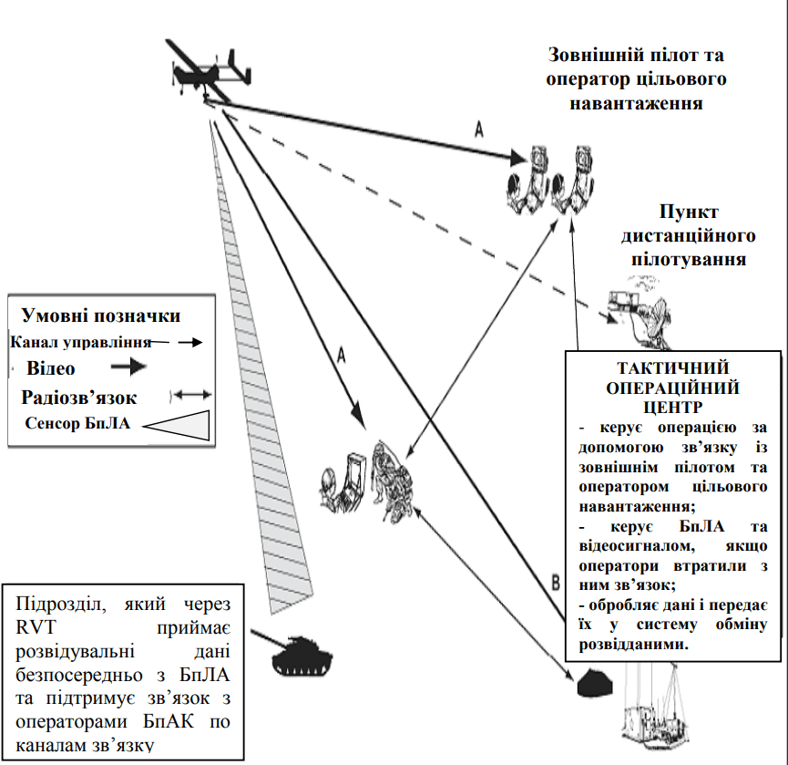
To ensure full integration of command and control systems, UAVs are classified into classes I, II and III. All participants must clearly know the communication procedures, video transmission rules, the features of the data transmission channels, as well as understand the mechanisms for their configuration and maintenance during the performance of tasks.
Maximum efficiency of UAV use is achieved when intelligence data is received directly to the end user, and not through command centers or headquarters. This requires a high level of qualification of UAV crews and awareness of commanders in the capabilities and limitations of the systems.
These complexes are usually small, autonomous and portable. They are designed to support the missions of small tactical units and are usually operated by one or two operators who simultaneously control the device and monitor the image or video from the target load on portable devices.
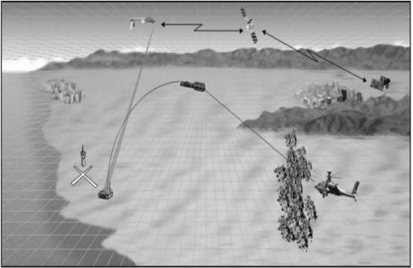
The limitations are the need for direct radio visibility for reliable control. A generalized control and control scheme for a Class I UAV is shown in the corresponding figure.
Мал 11 – C2 БпАК класу I.
These complexes are larger and are designed to support maneuvering actions of commanders at different tactical levels of control. At the same time, they can also be used to support small combat groups, depending on the nature of the tasks being performed.
Intelligence data from such UAVs can be promptly transmitted to combat units in real time through a single system of remote video terminals (OSRVT/Rover) or distributed among tactical elements operating in coordination or working on a common task. The collected information can be processed directly by specialists of UAV units or data can be transmitted directly to intelligence agencies.
Communication during the use of such complexes can be limited to the limits of direct visibility (LOS) or carried out through relay nodes, if the equipment has such functionality. A generalized diagram of the UAV class II command and control system is presented in Figure 12.
C2 airspace management allows for balancing the different needs for its use, while avoiding excessive restrictions on the effective use of UAV combat potential. Flight planners should pay primary attention to flexibility and simplicity of procedures to ensure maximum effectiveness in operating the system.
As a rule, established principles of manned aircraft traffic management apply to UAV operations. Tasks for UAVs should be considered at the early stages of developing air traffic control orders, aircraft employment orders, and in special instructions. The use of UAVs should comply with all agreed stages of planning, command, and execution procedures, depending on the circumstances.
Class I UAVs usually do not need to be included in an aviation task order if their operating altitudes do not create a risk of conflict with other air operations. However, tasks for Class II and III UAVs must be included in such an order to prevent possible conflicts in the airspace.
It is also worth considering that the adversary may produce or purchase UAVs in other countries, so C2 points must be able to identify friendly UAVs, enemy aircraft, and cruise missiles.
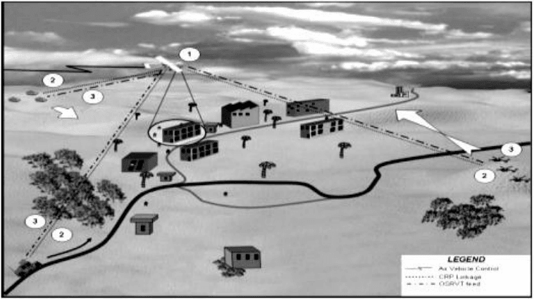
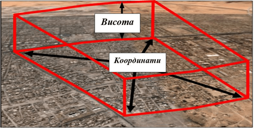
Limited operational areas can be established over areas where intensive use of various types of aircraft is expected, for example, within urban operations. Such areas are defined for the entire theater of operations through an air traffic control order. Information about the OZ includes contact frequencies for aircraft flying through the area, coordinates of brigade-level fire units, directions of fire, and aircraft activities within the OZ. An example of establishing a limited operational area is shown in Figure 13.
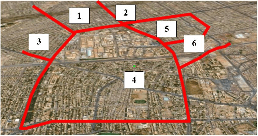
Zonal Security System – Ground units may develop a zonal security system, using security zones based on unit boundaries, population density, geographic areas, or any system that facilitates conflict prevention in the airspace for maneuver elements. An example of a zone is shown in Figure 14.
The analysis shows that the use of unmanned aerial systems during the Joint Operational Operations (formerly ATO) has become a key factor in increasing the effectiveness of tactical and operational operations. Due to the ability of UAVs to perform a wide range of tasks – from aerial reconnaissance to artillery fire correction and direct air support – units have gained significant advantages in operational awareness, speed of response and accuracy of combat operations.
At the same time, the integration of UAVs into the overall combat control system requires a high level of crew training, clear interaction between units and careful planning taking into account weather conditions, terrain, threats from enemy air defense and electronic warfare. Practical experience has confirmed: the more carefully coordinated the actions of unmanned and manned systems, the higher the effectiveness of combat operations.
Having completed the review of general concepts, planning procedures and basic principles of UAV application, we will now proceed to an in-depth analysis of the organization of communications, the features of the technical operation of the complexes and the formation of checklists for planning tasks based on the combat experience of the Joint Forces.
To be continued in the second part.