
In this article, you will learn how satellite data and OSINT analysis were used to establish the location and context of the events near Al-Fashir. The article examines one of the most resonant episodes of the conflict in Darfur – an event that was recreated using geolocation, satellite images and open source analysis. You will learn how experts established the exact location of the tragedy, what evidence was key and why this case attracted the attention of human rights organizations around the world. The article shows how modern OSINT tools help document crimes even where there is no physical access.
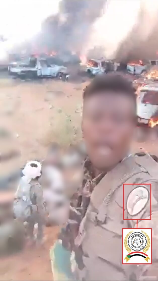
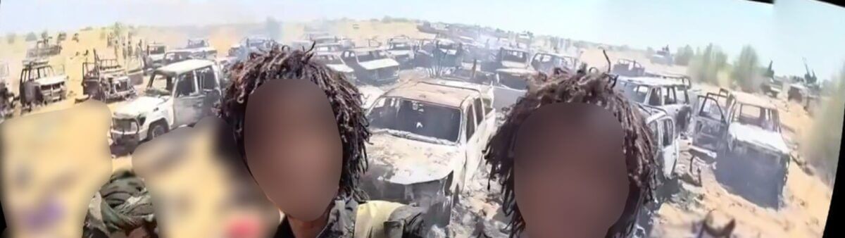
During the recent siege and subsequent capture of Al-Fashir by the paramilitary Rapid Support Forces (RSF), the exact location of the massacre of over 80 people was determined by analyzing a large amount of video footage that began to appear online after October 27. Some of the footage shows armed individuals wearing RSF-style uniforms and insignia, while the footage itself shows the course of events and their aftermath at the scene of the tragedy.
El Fashir, the administrative center of North Darfur, remained the last significant stronghold of the Sudanese army in the region and a refuge for people fleeing from surrounding settlements. The city was strategically important due to its location on the southwestern route leading to Chad and South Sudan. After more than 500 days of blockade, it came under the control of the Rapid Support Forces (RSF) last week. The Sudanese Medical Network estimates that at least 1,500 people were killed in the assault, as the RSF is engaged in a fierce confrontation with the Sudanese military for power in the country.
Open-source evidence seen by Bellingcat has shown that people trying to flee Al-Fashir were being killed by men, some of whom appeared to be wearing Republican Security Forces (RSF) uniforms. The RSF had previously pledged to remain “firmly committed to protecting civilians” and “not tolerate any attempt to exploit their lives or compromise their security.”
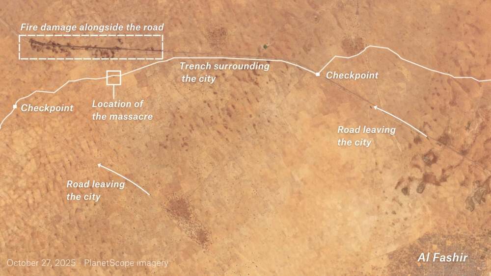
A video posted on social media shows the massacre seven kilometers from the city, where a convoy of refugees came across an earthen embankment surrounding Al-Fashir. The embankment and accompanying trench were built by the Republican Security Forces during the siege. Satellite images show that the area northwest of the city where the massacres took place was under construction during August.
More than a dozen videos were reviewed, but due to the extremely violent nature of most of the scenes, only footage without overtly graphic content was included in the final material. Some of the videos filmed in this area were additionally confirmed at the location by specialists from the Information Resilience Center and other analytical groups.
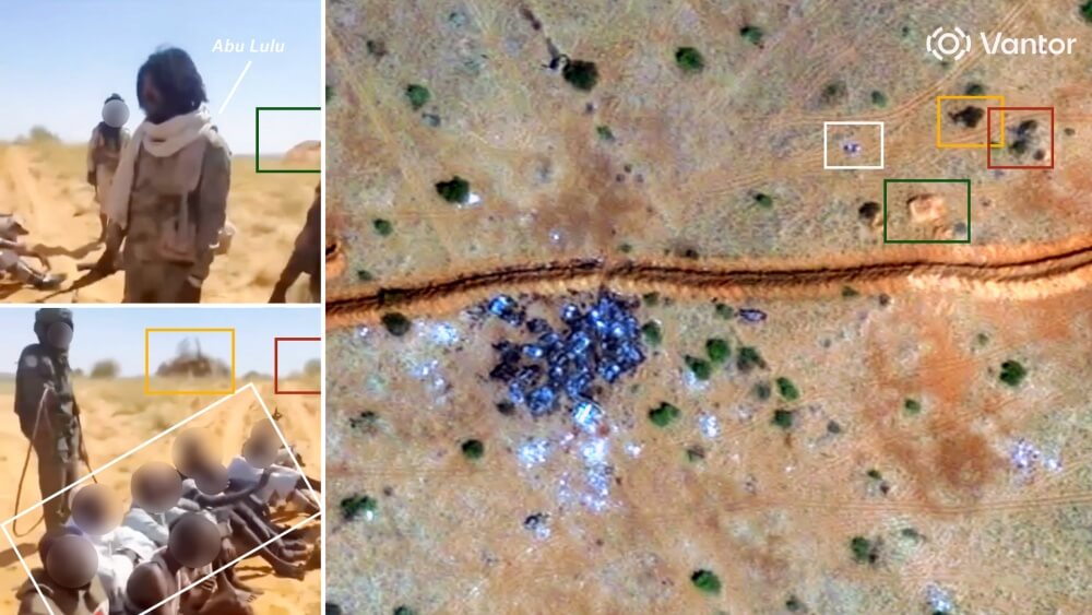
Comparison of angles from different cameras made it possible to accurately establish the coordinates of the massacre site: 13.71340, 25.27854. In satellite images, dark clusters of figures near the destroyed vehicles located north of the earthen embankment coincide with the positions of the bodies visible in verified videos from the location.
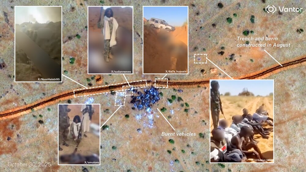
The released videos show more than 80 dead lying next to smashed and burning cars, along the embankment, inside the nearby trench and in the surrounding area. There are also more than two dozen completely destroyed vehicles.
One video, taken at the initial stage of the attack, shows armed men in uniforms similar to those of the Rapid Support Forces, taking cover behind a car during intense gunfire. The footage also shows one of them approaching the burning column and aiming his weapon.
However, in later recordings made after the attack, no people with weapons are seen among the dead; almost all of them are dressed in civilian clothes, including women. Of the more than 80 bodies recorded, only a few were wearing dark, military-style clothing, and next to one person was a belt of ammunition – but it is impossible to determine who it belonged to.
The location of the destroyed cars and groups of dead in the video completely coincides with what is visible in the satellite images. In addition, tire tracks in the sand probably lead from the scene of the massacre to several checkpoints along the earthen embankment. New tracks were found in satellite images taken after October 27, the day the city finally came under the control of the rapid support forces.
The unit commander, known as Abu Lulu, who is identified in the video by his distinctive white scarf, appears in at least three recordings made at the scene. He has previously appeared in videos from the war zone that have been shared on social media. On October 31, TikTok removed an account believed to belong to the individual.
In one video, filmed from the other side of the rampart, the commander can be seen and heard taunting ten captured men, forcing them to praise the Rapid Support Forces and humiliate the army before being executed.
Another video, filmed to the west of the convoy, shows Abu Lulu interrogating a wounded man lying on the ground, threatening to sexually assault him before shooting him at point-blank range. A third video, filmed a few meters from the convoy, shows the same commander standing among several still bodies and repeatedly shooting them.
Several other videos show one fleeing vehicle crossing a ravine before getting stuck in a trench on the opposite side. One of these videos, filmed from inside a trench, shows a fighter shooting at a group of still bodies on the ground next to a vehicle while others film and celebrate.
Morris Tidball-Binz, the UN Special Rapporteur on extrajudicial and arbitrary executions, said that if the material released is authentic, it amounts to “unlawful killings that violate international human rights law, international humanitarian law and international criminal law.”
In his view, such acts fall within the definition of extrajudicial killings, are considered war crimes and could potentially be classified as crimes against humanity, given the number of victims and the likely systematic and planned nature of the killings.
He also noted that he was not aware of any real steps taken by the Rapid Support Forces leadership or other competent authorities to investigate the incidents or punish the perpetrators. “There is currently complete impunity,” he stressed in his letter.
A video from October 30 shows Abu Lulu being detained, escorted under heavy security, and taken to Shala prison on the western outskirts of the city. The Rapid Support Forces have announced that they are investigating “abuses” allegedly committed by their fighters since the capture of Al-Fashir.
Other open sources have also provided evidence of abuses in the city. A special analytical report by the Yale University Humanitarian Research Laboratory on October 27 found objects resembling human bodies near equipment, as well as areas of land with a reddish color.
The UN Security Council condemned the Rapid Support Forces attack on Al-Fashir and its devastating impact on civilians.
The UN Fact-Finding Mission in Sudan said it was “deeply concerned by the escalation of crimes,” describing “a large-scale pattern of brutality by both sides in the conflict.” The mission’s initial findings include deliberate ethnically motivated executions of unarmed civilians, attacks, sexual violence, widespread looting, destruction of critical infrastructure, and massive forced displacement. The Rapid Support Force is now in full control of Darfur.
The report shows that satellite imagery, open-source video and geolocation analysis have been used to reconstruct one of the most horrific episodes of the fall of Al-Fashir. The evidence gathered points to mass killings of civilians and people trying to flee the city, as well as the involvement of Rapid Support Forces fighters in these events. Data from various sources — from OSINT analysis to UN statements — point to possible war crimes and the systemic nature of the violence. Despite some statements about an investigation, there is no actual responsibility, and the Darfur region remains under the full control of the Rapid Support Forces.