
In addition to aerial reconnaissance, intelligence networks, scouts, as well as records from social networks, in which users often add photos and video materials, to identify firing positions and locations of the enemy’s army, it is used. In such materials, it is necessary to determine the exact location of the shooting and the coordinates of the object being shot, but there is usually no metadata with geodata. Then you need to resort to the methods of geospatial intelligence and GEOINT. To do this, you need to carefully analyze everything that got into the frame – the relief, the nature of the underlying surface, the direction of the shadows, the location of the stars, the location of the buildings, their configuration and details.
It is also important to know the date and time of shooting, if it is not possible to confirm the date of shooting (the date of shooting is not the same as the date of publication of the analyzed content, and not the same as the date of content analysis) – this should be taken into account in the conclusions. Next, we will consider an example of video analysis published in a regional Telegram channel. Video of a rocket launch in Donetsk – from a post in the Telegram channel: https://t.me/itsdonetsk/12617 The date of publication of the video is known for sure, 04/23/2022, the nature of the vegetation coincides with that typical for this city at this time of the year, i.e., the launch date of rockets may coincide with the publication date of the video. Let’s move on to the analysis of the key frames of the video. It is convenient if you download the video and use a player that allows you to view the video frame by frame, for example: GOM Player, VCL Player, etc. Now let’s try together with you to determine the location of the rocket launch.
The shooting point is at some height above the ground. Let’s pay attention to the location of the garages in the frame and several of them (on the right) have white roofs. the wall of the temple and the dome were also included in the frame on the right. In the direction of the rows of garages, high-rise buildings with a white and red facade are visible, located perpendicular to each other. on the horizon, there are 2 hills (most likely Terikon) at different distances. It can be seen that the launch point of the rocket is in front of the near tericon. Open the Google map of Donetsk, turn on the display of the image from the satellite. We are looking for a video shooting point, it should be a place where a garage cooperative, a temple and a tall building are located nearby. Maybe it’s all in the Leninsky district.
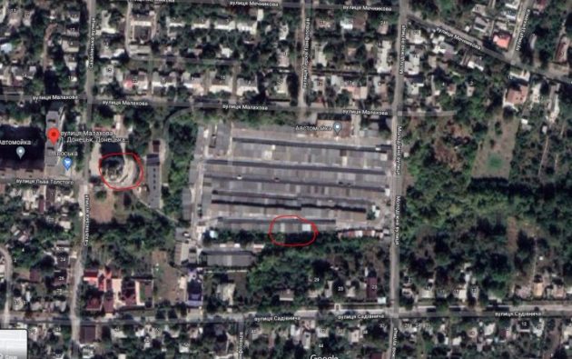
After a short search, we find Svetlo Useknovenskyi Temple and the point (47.952805125445444, 37.79466636859943) where the video was shot:

47.952805125445444, 37.79466636859943 Everything is here – the temple, garages, and the high-rise building with which the note was kept.

A frame with the rocket launch site. Let’s pay attention to the two houses standing on the same line as the missile launch point, on the map it is (47.949244, 37.810311)
Next, after laying a straight line from the observation point, through a couple of houses, to the tericon, we will determine the approximate place of the air defense launch (blue ellipse).
This was an example of content analysis and finding geographic coordinates. If you received the coordinates, check them again. It is impossible to allow a situation where you take what you want for granted. If you have checked and there is no doubt that everything is correct, then send the result and the most important thing – the progress of your research to the bots:

