
02.07.2024
4 min
1375

During the declared ceasefire in Myanmar after the earthquake, the army continued attacks on civilians. Dozens of villages, including schools and hospitals, were hit by airstrikes. There are reports of destruction of infrastructure and civilian casualties.

At least 22 villages have been identified as damaged by airstrikes in Myanmar, despite a temporary ceasefire declared by the State Administrative Control (SAC) or military junta from April 2 to 22 following a 7.7-magnitude earthquake that struck the country on March 28. The ceasefire has been extended until April 30.
The epicenter of the earthquake was located just 16 km northwest of Mandalay, Myanmar’s second largest city, and struck shortly before 1:00 p.m. local time. More than 3,000 people have died, and aid groups say more than 17 million people living in the quake-hit areas are in urgent need of food, water, shelter and medical assistance.
The country, already reeling from four years of civil war, continues to be hit by multiple shocks. The State Administration of Myanmar (SAC), which has ruled Myanmar since seizing power from a democratically elected government in 2021, announced a temporary ceasefire only after the main opposition coalition announced it would – except for defensive actions.
At least 19 villages were recorded as damaged by airstrikes during the first 20 days of Myanmar’s official ceasefire. Two more villages have been confirmed through local reports. Three villages were previously hit between the earthquake and the start of the ceasefire. In total, 22 settlements have been identified as having suffered damage.
The attacks have mainly targeted civilian areas located in areas controlled by opposition forces or where the military is seeking to retake control. The identification of the affected villages was done by comparing satellite images (including NASA FIRMS) with reports from local media and independent sources.
“These are airstrikes, and it is clear that only the army has aircraft. The insurgents do not have such capabilities,” said Ai Chan Naing, co-founder of one of Myanmar’s largest independent media outlets, commenting on the situation.
Lacking jets or fighter jets, the resistance groups are relying heavily on commercial drones, “improvised for military use,” Naing said.
He explained that attacks on and intimidation of civilians are part of the military’s strategy. “If you support the insurgents, you know we [the military] will burn the village.”
“At a time when the only focus should be on ensuring humanitarian aid reaches the disaster areas, the military is instead launching attacks,” said Ravina Shamdasani, a spokeswoman for the UN Human Rights Office, on April 11.
“The military has reportedly carried out more than 120 attacks since the earthquake – more than half of them since the ceasefire was due to take effect on April 2,” she told reporters.
According to local media reports, the Myanmar military launched an airstrike just hours after the earthquake. The anti-Khuntwin armed group, the TNLA, said the military bombed the village of Nawng Len, about 120 km from the epicentre of the earthquake in eastern Shan State. The attack reportedly killed seven members of the TNLA-affiliated Ethnic Armed Organisation (EAO).
We were unable to independently confirm the airstrike, but we were able to geolocate images of several damaged buildings in the north of the village. The intact buildings can be seen in Google Earth imagery from late January.
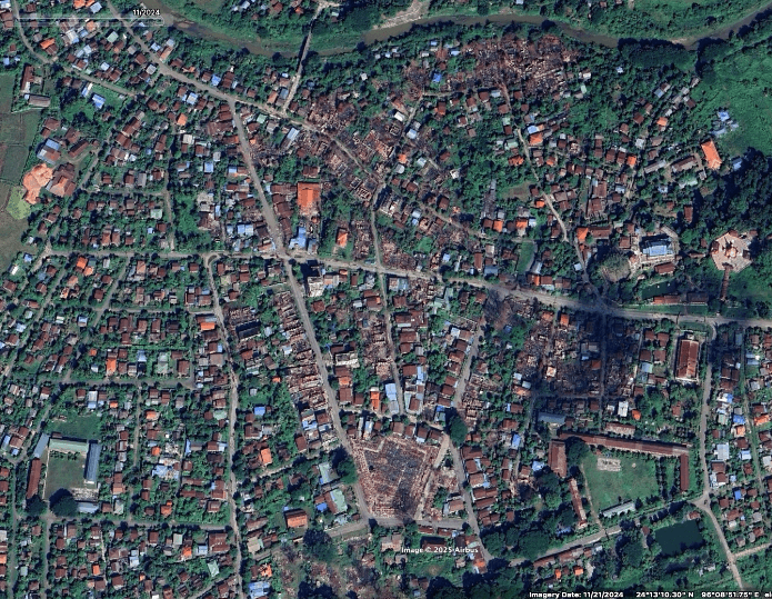
Of the 22 villages we identified, 14 are in either Sagaing or Mandalay, which were among the areas hardest hit by the earthquake. Large parts of both regions are in central Myanmar, where many settlements are either disputed or under junta control.
The military is trying to cut off the insurgents’ livelihood. “They understand that the insurgents cannot survive without the civilian population because that’s where they get their food and maybe their tax money,” he said.
Because the insurgents don’t have permanent bases, their members are hard to find. While drone strikes can kill a few people, it’s much easier for the army to spot and attack areas where civilians live, Naing added.
On April 9, an airstrike in Nan Khan, Wunto Township, Sagaing, reportedly killed twenty people. We were able to geolocate images of damaged buildings at coordinates 23.9983922, 95.8881422.
Days before the attack, on April 6, an airstrike was reportedly carried out on the village of Tone Pan Hla in Chaung U township, killing three members of a family. “The motivation for this attack on a village of melon farmers is difficult to understand. It appears to be an attempt to terrorize the civilian population, who strongly support the anti-government Government of National Unity (GNU) and its armed rebel wing, the PNA,” The Times reported. The GNU is the country’s parallel government in exile, democratically elected and ousted in a 2021 coup.
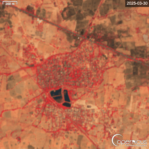
About 25 km northeast of Tone Pan Hla is the village of Ngar Shan, also in Chaung U township. Local media reported that the village was burned down by the junta just days after the earthquake. Although we were unable to geolocate specific images or independently confirm the cause of the fire, thermal hotspots were detected at the site of the fire on March 31. This is consistent with the timeline and reports of 170 homes burning in Ngar Shan on April 1 local time.
Images of the destruction posted on Facebook show the village in ruins. However, NASA’s Fire Information for Resource Management System (FIRMS) detected thermal hotspots throughout the village on the morning of that day.
A false-color infrared map from the Copernicus Sentinel Hub also shows signs of damage in the village. While this type of imagery is typically used to assess vegetation, areas covered with vegetation are shown in deep red, while towns and open land are shown in gray or brown, and water appears blue or black. After the attack, open land, indicating possible damage, can be seen mainly in the northwest of the village.
Chaung-U Township is located in the southern Sagaing region, where geography poses challenges for resistance armies.
“Unlike ethnic resistance groups along Myanmar’s borders or those in northern Sagaing near India, resistance forces in southern Sagaing have no foreign borders through which they could attempt to retreat,” the Resilience Information Center wrote in a December 2024 report by Myanmar Witness.
Sagaing remains an epicenter of violence, with a strong resistance presence due to the region’s strategic importance. A state of emergency was declared in the state following the earthquake.
Another strategically important region is Mandalay, where the Central Military Command is located in the Mandalay Palace, which was reportedly damaged in the earthquake. Mandalay is also a logistics hub in the heart of Myanmar, and since late last year, the SAC has been trying to recapture lost settlements there.
Two of these settlements are Thabeikyin and Singgu. Both were attacked during the ceasefire.
On April 19, the Myanmar military reportedly carried out an airstrike on the village of Yae Htwet in Thabeikyin township. According to the BBC, at least 27 people were killed in the attack. The report added that pro-military Telegram channels claimed that the attack was directed against camps of the PDF, the armed wing of the anti-government National Unity Government.
Just a day earlier, 13 people were reported killed in an attack on the village of Lek Kya, 3 km north of Yae Htwe.
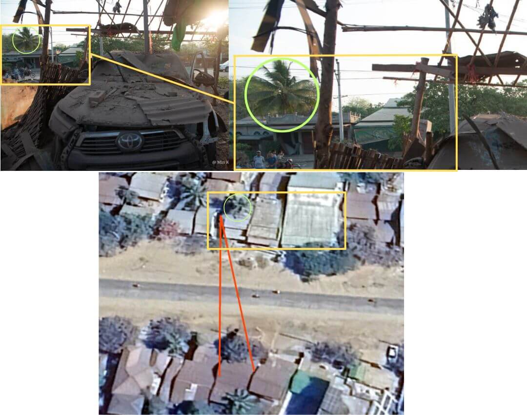
A separate airstrike was reportedly carried out on a village in Thabeikyin, killing two people. It occurred on 13 April in Chaungya, along the highway that runs through the village. We were able to identify distinct features on the roofs of buildings opposite the attack site and, together with the location of trees, compare satellite imagery of the area.
The geolocation of a school (here:22.689505, 96.016978) in Xingu Township was also discovered, where an airstrike was reportedly recorded in Zhi Tauk Pau village, injuring six people.
The junta has a history of attacking schools. According to a Radio Free Asia estimate last November, nearly 200 schools have been hit by airstrikes since the 2021 military coup in regions and states where resistance forces opposed the junta have been fighting.
On April 20, a school in the village of Shwebo in Sagaing was reportedly shelled during a ceasefire, killing two people, including a pregnant woman. According to DVB, the People’s Administration of Shwebo, a local government body opposed to the junta, said that displaced persons were hiding in the school.
Four schools and seven religious sites, including monasteries and churches, were found to have been damaged in the recent attacks.
Peter Bouckert of the human rights group Fortify Rights called the attacks on churches and monasteries that could have been hosting people displaced by the earthquake “a grave violation of the laws of war.”
“These are facilities protected by international humanitarian law. These are direct, deliberate attacks on these protected facilities.”
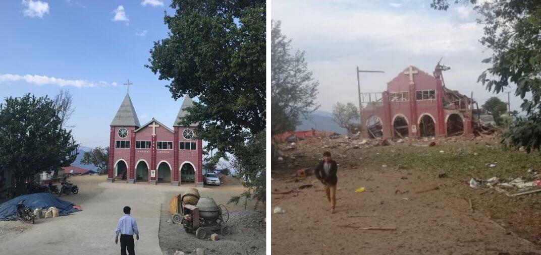
The junta has a history of attacking religious sites. During the ceasefire, a Baptist church was blown up in Mindat, in neighboring Chin State, where several armed opposition groups have emerged since 2021. While there were no reports of casualties at the church, six people were killed in the attack on the town.
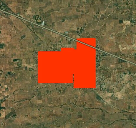
Mindat was captured by the resistance last year, amid reports of hundreds of homes destroyed by alleged junta shelling, arson, and airstrikes. Much of this damage is now visible in updated Google Maps imagery from January 2025.
As Myanmar Witness discovered in 2023, several churches in Chin State have been damaged in recent years. It is the only Christian-majority state in Myanmar, where the majority are Buddhist.
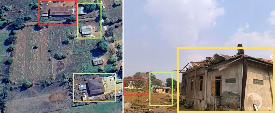
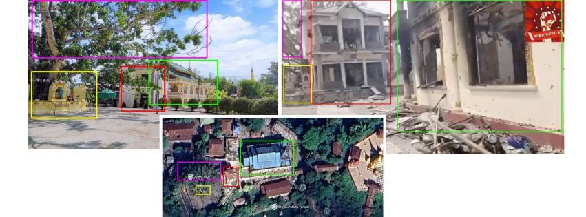
Indau is a small town near the border with Kachin, a state that is partially controlled by resistance forces led by the Kachin Independence Army (KIA). Indau was reportedly bombed on April 1, while it was still under junta control. According to local residents, two people were killed and eight were injured. The attack damaged a monastery. We were able to geolocate images of the aftermath by comparing old photographs and satellite images of the monastery with structures still standing after the recent attack.
The destruction on April 1 was just one of many attacks the city has seen since the resistance offensive began last August. The junta’s airstrikes on the resistance have reportedly forced hundreds of people to flee their homes, while many others have fled.
Despite the ceasefire, resistance forces captured Indau on April 8 after months of fighting. However, the junta is reported to continue airstrikes on civilian areas.
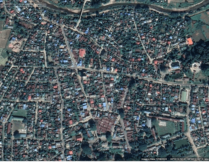
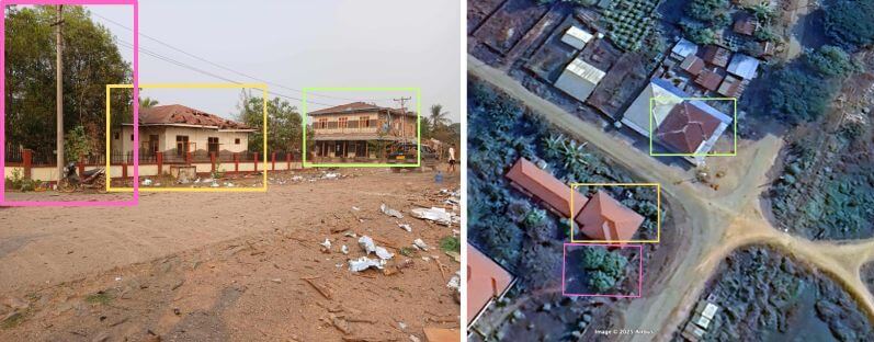
Images show that much of Indau was destroyed last year. Source: Google Earth Pro image
The military regime reportedly carried out airstrikes on monasteries during the four-day Thingyan, or Burmese New Year, celebrations from April 13 to 16. At least 23 civilians were killed in the attacks, according to data compiled by the independent news website The Irrawaddy.
One attack on a monastery reportedly killed six people and injured 20 others.

The Myanmar military has extended a ceasefire until April 30 to “accelerate relief and reconstruction”, but aid is reportedly being limited. “The SAC is using humanitarian aid as a weapon”, said Surachani Srijai, acting director of the Centre for Sustainable Humanitarian Action for Displaced Ethnic Communities, explaining that aid is not reaching areas not under SAC control. A BBC analysis last November found that the military has full control over only 21% of Myanmar.
Srijai noted that while the earthquake has brought some attention to Myanmar, the country is already in dire need of aid due to its long-running armed conflict. Meanwhile, bombings continue even during the extended ceasefire.