19.11.2023
8 min
1659

Satellite images obtained in January 2025 show significant destruction of civilian infrastructure in the northern Gaza Strip. During the three-month military operation by the Israel Defense Forces (IDF) that began in October 2024, more than 80% of facilities intended for internally displaced persons, including schools and hospitals, were damaged or destroyed.
Thousands of people have begun returning to their abandoned homes in northern Gaza since Israeli forces opened the Netzarim corridor, which separates the north and south of the territory, on January 27.
After lengthy negotiations between Israel and Hamas, a ceasefire agreement was reached, which was announced on January 15 and came into effect on January 19.
“We want to return home… Even though my house is destroyed, I miss my land and my place,” said a Palestinian from the Al-Shati refugee camp.
However, new satellite images and footage from the scene show that in many areas of northern Gaza, there are simply no homes to return to. Schools and hospitals, which previously served as temporary shelters for civilians, have also been severely damaged.
According to the UN, as of November last year, there were at least 50 facilities in northern Gaza hosting internally displaced persons, most of them educational institutions. More than 80% of these facilities have been damaged or completely destroyed during the three-month fighting that began in October.
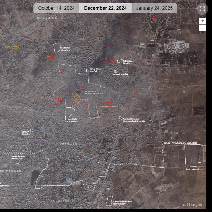
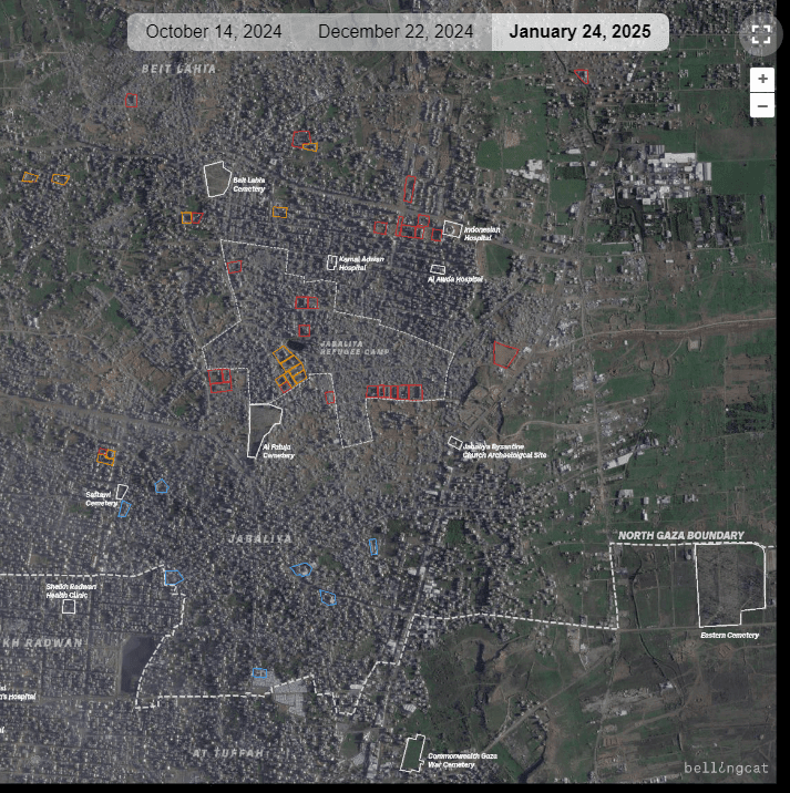
Analysis of satellite imagery, photographs and video footage from the scene shows extensive destruction in the towns of Beit Hanoun, Beit Lahia and Jabalia.
Traditionally, schools have served as temporary shelters for displaced people during previous escalations of the conflict in Gaza. A November UN report cited 50 such facilities: 45 schools, two health facilities and three tent camps set up during the summer. All of these locations were mapped as areas used to house civilians.
Today, most of these facilities are severely damaged or completely destroyed, further complicating the humanitarian situation in the region.
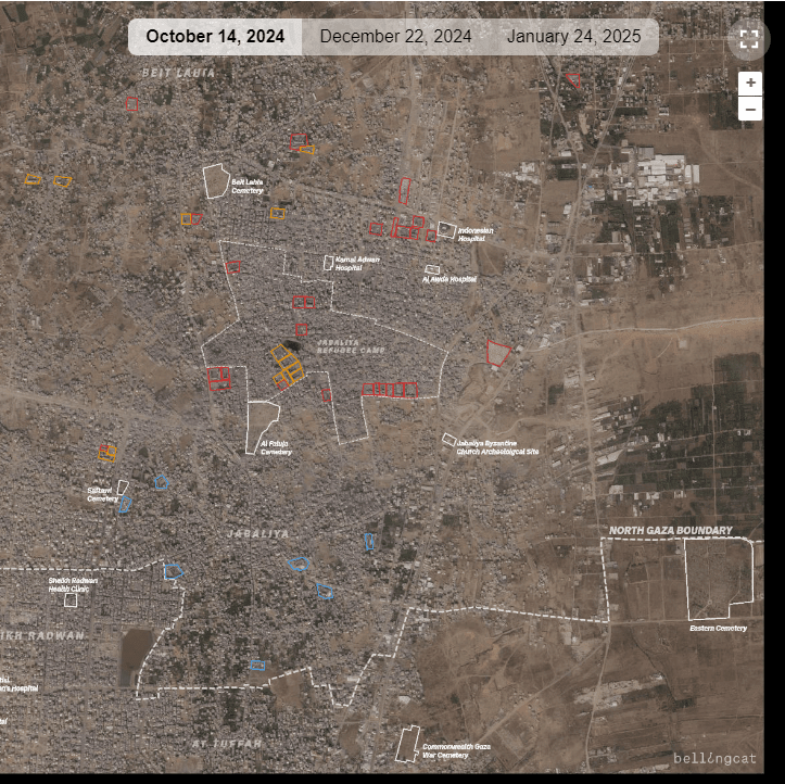
The first image is dated October 14, 2024, after Israeli forces had already begun a renewed operation in the area.
The second image is dated December 2024, after extensive destruction throughout the area.
The last image is dated January 24, 2025, at the beginning of the ceasefire, showing groups of Palestinians returning to the area on the streets. Blue outlines are former IDP sites identified by the UN that have been assessed as intact. Orange outlines are former IDP sites with damage nearby or in the area. Red outlines are former IDP sites that have been severely damaged by fire or completely destroyed.
The report did not include three major hospitals located in northern Gaza: Kamal Adwan Hospital, the Indonesian Hospital, and Al-Awda Hospital. Although the first two were out of action in early January due to active fighting, they had previously provided care to patients and served as shelters for displaced persons.
Of the 50 facilities documented in the UN data, only eight were reported to have no visible damage. Twenty-eight were completely destroyed or severely damaged, while another 14 had partial damage or damage in the immediate vicinity, compared with previous reports.
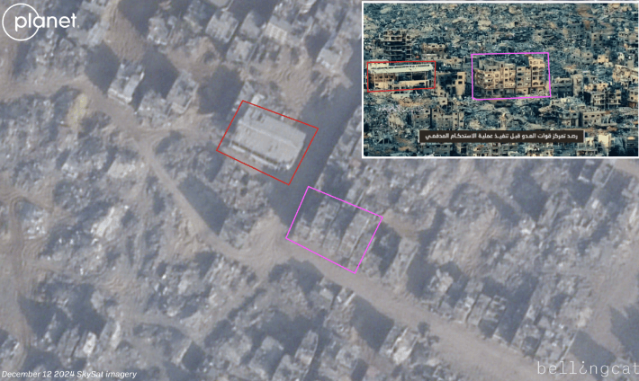
Several of the heavily damaged areas show signs of extensive fires. Three tent camps that were captured on satellite imagery before the military operation began have been completely destroyed. The largest of these camps contained about 250 tents. After its destruction, a military position with defensive structures and armored vehicles was deployed at this location, as confirmed by satellite images.
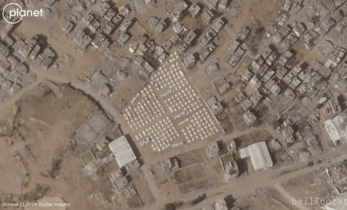
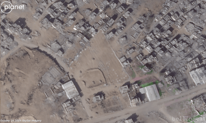
Planet Labs satellite images before and after show the site of a large tent camp for internally displaced persons (IDPs) on the outskirts of Jabalia in northern Gaza. After the IDF launched an operation in the area, the tents were cleared and military positions were set up.
When asked about the locations of the IDPs, the IDF said Hamas “systematically violates international law” and uses civilians as human shields.
According to the UN, at least 14 schools that were previously used as temporary shelters for displaced people have been damaged by fire, according to satellite imagery, as well as photos and videos circulating online.
Five of the destroyed schools are located within 500 meters of an Indonesian hospital, which has been the scene of intense fighting since October. Satellite imagery shows significant damage to the following schools: Kuwait School, Girls’ Preparatory Schools A & B in Beit Lahia, Al-Ghertani Secondary School, Hamad Ibn Khalifa Secondary School for Girls, and Aleppo Schools A & B. These schools have been damaged by fire or partially destroyed by fighting.
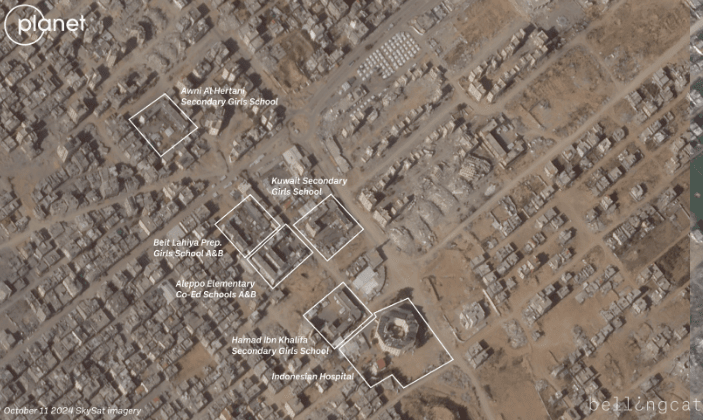
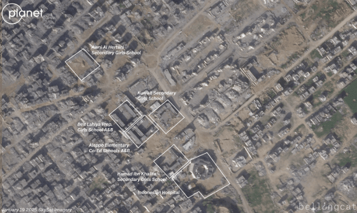
Before-and-after satellite images from Planet Labs show an area of northern Gaza near an Indonesian hospital. Between October and January, tents for internally displaced persons were dismantled and several schools were either severely damaged or destroyed.
A drone video posted on October 19 by an IDF Arab spokesperson on X shows a Kuwaiti school with groups of displaced Palestinians and IDF armored vehicles in the background. Another drone video posted four days later, on October 23, by the same account, shows the Kuwaiti school again in the background, this time with a large fire and a large group of displaced Palestinians gathered on the school grounds.
A photo posted on X by Palestinian journalist Younis Tirawi on October 20 shows the Kuwaiti school on fire, with IDF soldiers posing in front of the burning buildings. Another photo posted by Tirawi on October 21 and geolocated by volunteers using Geoconfirmed, a community-based geolocation platform, shows School B in Aleppo, another school not far from the Kuwaiti school, burning.
Al-Fallujah Girls’ High School was visibly burned in an image posted online in mid-November, showing dozens of Palestinian detainees sitting in front of it in white jumpsuits. SkySat imagery from Planet Labs showed another school burning on December 9, billowing a thick column of black smoke and red flames.
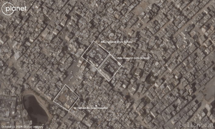
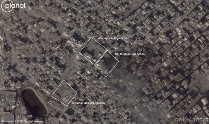
Planet Labs satellite images before and after show part of the Jabalia refugee camp. In the December 9 image, one of the two schools in the image has a large plume of smoke and what appears to be a fire on the school grounds.
The IDF did not respond to multiple requests for comment on the burned schools.
According to data from the non-profit Education Cluster as of December, all school buildings in northern Gaza have been damaged or destroyed. The organization’s report also states that as of October 7, 2023, nearly 88% of schools in the entire Gaza Strip (496 out of 564) will need either full reconstruction or major repairs to be able to resume operations.
The main difference in data collection approaches is that the Education Cluster considers the entire period of the conflict, starting in October 2023, while other estimates only capture destruction that occurred in recent months.
During the military operations in northern Gaza, both the IDF and militant groups such as Hamas’s Al-Qassam Brigades and the Palestinian Islamic Jihad’s Al-Quds Brigades released videos showing the activities of both sides.
A mid-December video from the Al-Quds Brigades showed mortar fire on IDF positions in central Jabalia at 31.5290, 34.4932. Another December video, this time from the Al-Qassam Brigades, showed an improvised explosive device (IED) attack on Israeli soldiers about one kilometer north of the Indonesian hospital.
The Israel Defense Forces have released numerous updates on their operations in northern Gaza, including several videos of tunnel destruction.
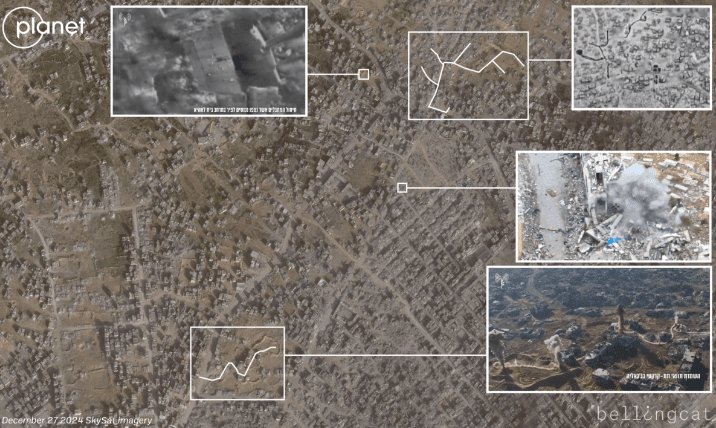
One video released by the IDF in December shows the destruction of the Zaid Ben Harith Boys’ Elementary School.
In another video, the IDF claims to have found several weapons at an unnamed school in Jabalia that was used by militants. The interior of the building appears to have been damaged by fire at some point. It is unclear whether this occurred before or after the weapons were found inside.
At least three schools investigated in this investigation have also been targeted by what the IDF says are Hamas or Palestinian Islamic Jihad.
According to official figures released by the Israel Defense Forces and Times of Israel military correspondent Manny Fabian, about 10% of the total Israeli military casualties since the start of the war have been in northern Gaza during the latest military operation.
One of the key terms of the ceasefire agreement was to allow Palestinian civilians to return to their homes, including in northern Gaza. SkySat satellite images from Planet Labs taken on January 19 showed people beginning to return to the areas, despite the extensive destruction. The images show civilians and vehicles moving through the destroyed streets.
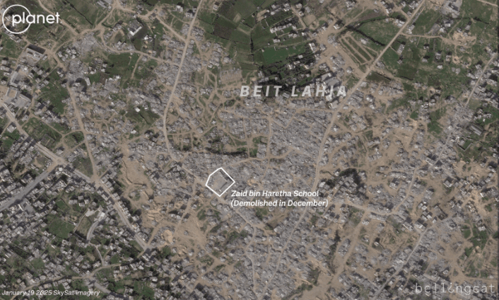
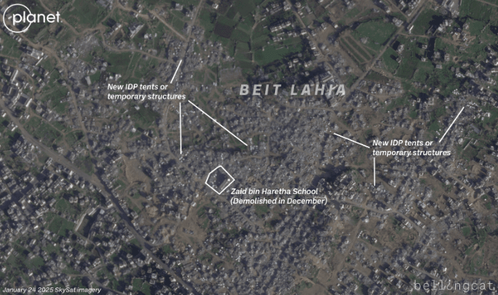
Before-and-after satellite images from Planet Labs show a heavily damaged section of Beit Lahia in northern Gaza. After a ceasefire was declared and Palestinians were allowed to travel north again, white tents have begun to appear among the rubble and destroyed buildings.
In areas where residential buildings once stood, people appear to be setting up temporary shelters. SkySat satellite images taken on January 24 captured a large part of the destroyed town of Beit Lahia, where white tents appeared scattered across the landscape just days after the ceasefire went into effect. This suggests that displaced residents are trying to return and adapt to their new conditions in the semi-destroyed areas.