24.04.2023
4 min
2263

Learn how the Shadow Finder tool helps geolocate images based on shadow analysis, using objects in the photo to determine the exact time and location of the photo. The accuracy of the results depends on the quality of the image and the correctness of the perspective analysis.

Geolocation is often time-consuming, with researchers spending hours searching for the right location by looking at satellite images and streets. But there is a way to narrow the search area faster. With the new Shadow Finder tool, you can narrow your search from around the world to a few countries or locations using data about shadows and objects in images. This allows you to significantly speed up the process of identifying the place where the images were taken.
Researchers often use shadows on images to determine when and where they were created. Measuring the height of an object and the length of its shadow allows you to know the position of the sun in the sky. At any given time, there is one point on Earth where the sun is directly overhead—this is the insolation point. The further away from it, the lower the sun is in the sky and the longer the shadow from vertical objects becomes. This knowledge helps to accurately determine the position of the sun and, accordingly, the location.
If you know the date and time the image was taken, and you accurately measure the height of the object and the length of the shadow, you can calculate the possible areas where the photo was taken. Tools like SunCalc allow you to check these parameters manually, but new technologies are simplifying the process. For example, tools for automatic shadow analysis can greatly facilitate the task, performing calculations without the need for deep knowledge of geometry.
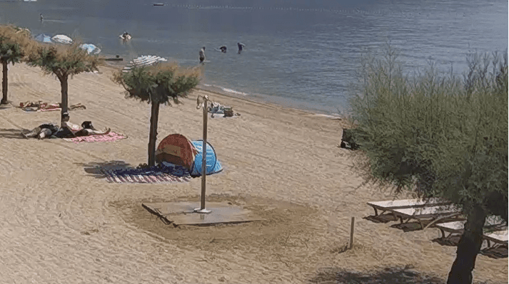
Let’s use Bellingcat’s shadow finder to narrow down the possible locations for this sunny seascape.
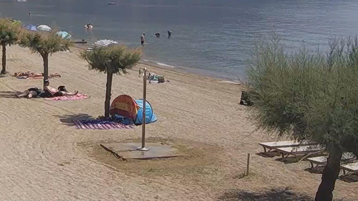
The first step is to determine the date and time the image was created. This can be the clock in the frame or the metadata of the file (you can use tools like Metadata2go or EXIFmeta to check). It is important to remember that metadata is not always accurate. If the date and time are known, they can be entered in UTC or local time. The tools will automatically convert the time to the correct time zone to perform geolocation. In the example of a picture from a live broadcast, the time is known precisely, which makes the search much easier.
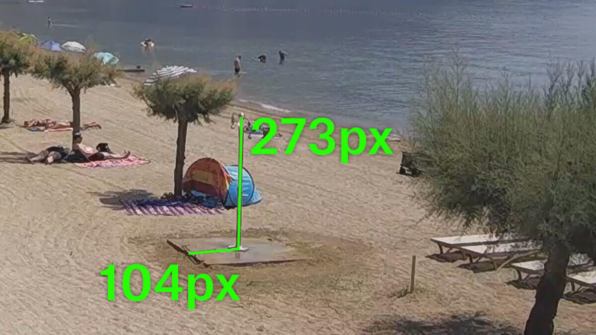
After confirming the date and time, it is necessary to identify a clear object and its shadow in the image. Measure the height of the object and the length of its shadow. Often these measurements can be taken directly on the image, but it’s important to consider perspective—the subject must be at right angles to the camera. For example, in the case of a beach shower that is vertical and has a clear shadow on a flat surface, the shadow can be measured directly. Distortion of perspective is minimal, as the shadow is located almost at right angles to the object.
Use an image editor (such as GIMP) or a ruler to measure the subject and shadow.
In our image, we can see that the height of the object is 273 pixels and the length of the shadow is 104 pixels. It doesn’t matter what units you measure in (you can measure in millimeters or inches), as we are interested in the proportion between the two measurements.
If you measure the object and the shadow in the same units, the Shadow Finder Tool will work.
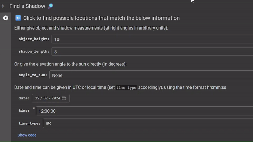
Now, with your height measurement, time, and date handy, open the shadow finder.
Enter the height of the object and the length of the shadow, as well as the date and time, and press “▶” to launch the tool.
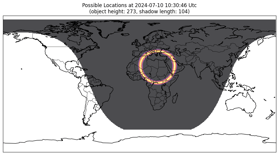
The tool will start (be patient, it may take a while to run the first time) and create a map.
The following points highlight the ideal conditions for obtaining the best results with the Shadow Finder Tool:
It is necessary to know the time and date of the image
The subject and its shadow should be approximately at right angles to the camera
The shadow should fall on the surface level with the horizon (flat floor)
The image should not be significantly distorted by the camera lens (as in the case of a fisheye lens).
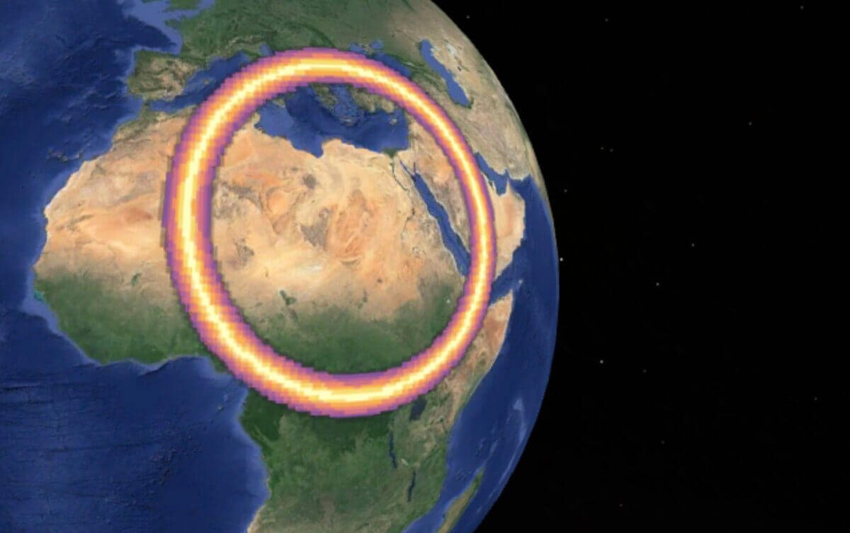
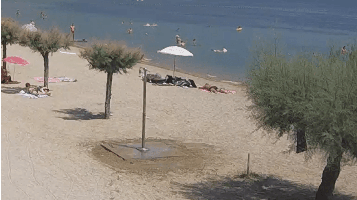
If you have multiple images taken at different times, you can further narrow down the location using the Shadow Finder tool. Here is another image taken from the same live stream the next day, a few hours later.
If you repeat the process and run the tool again, the new map will show a different set of possible locations as the Earth rotates and the sunspot moves. Combining the two maps with an image editor reveals where the rings overlap. This will help narrow down the number of possible locations to one or two places. Using this method greatly facilitates the process of geolocation.
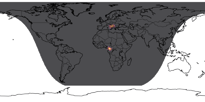
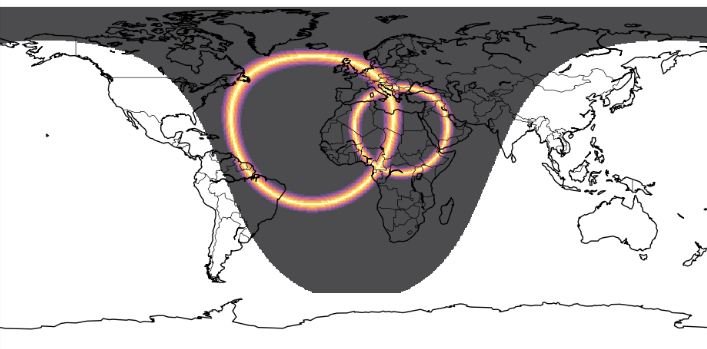
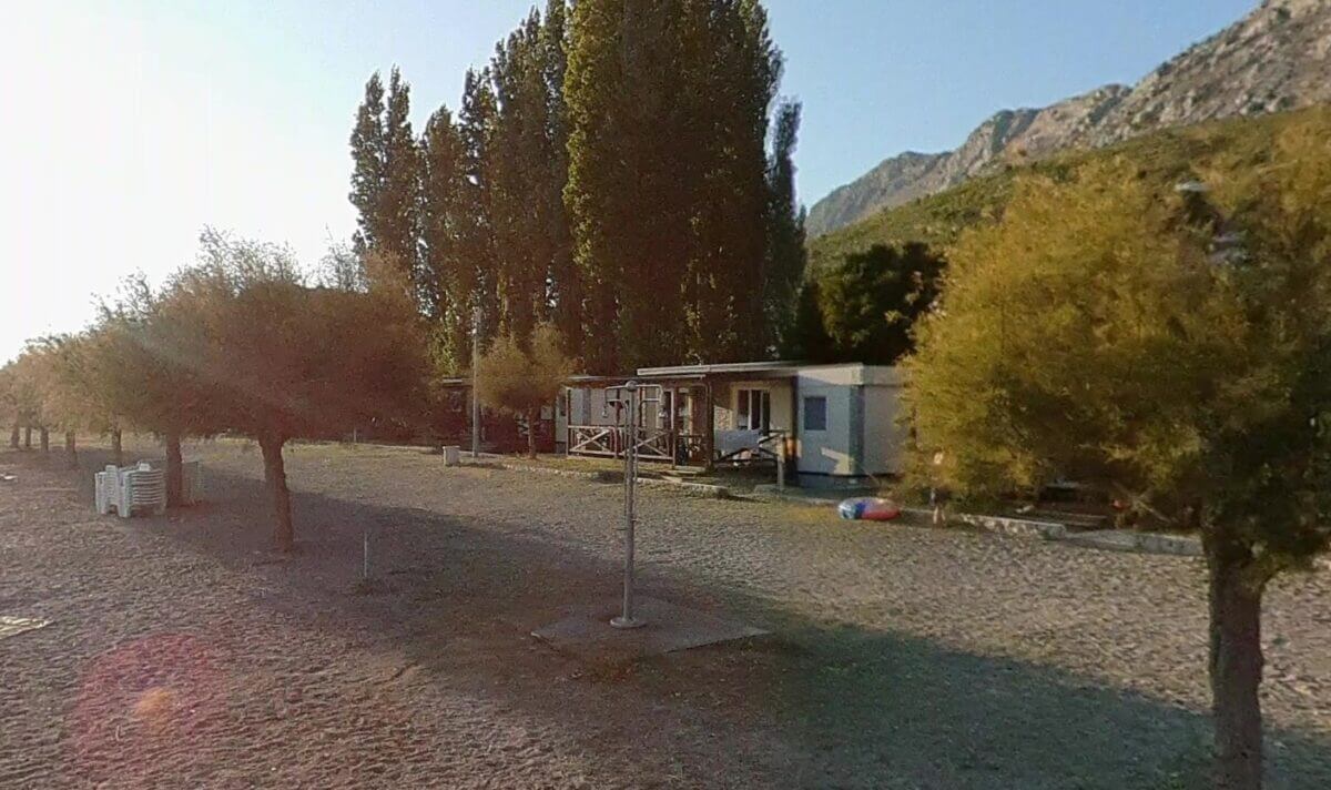
Overlaying the two maps showed only two possible locations: Cameroon and Croatia. Cameroon was excluded due to its lack of coastline, so the focus was on Croatia, especially the coast and islands near Split. Although there are many beaches, a methodical search helps to find the exact location. A webcam was even found in the images, which helped confirm the location.

When geolocating images, it’s important to consider context. There are other ways to narrow down the location of the image without using shadows. However, when the exact time and date are known and there is a clear shadow, shadow analysis can help quickly narrow down the search and point you in the right direction. If you want to use a tool like Shadow Finder, you can sign in with your Google account and get started right away.