17.04.2023
3 min
1330

The article analyzes in detail the shelling of the Ukrainian city of Mykolaiv by Russian rocket artillery with cluster munitions, which occurred on April 4, 2022. As a result of the attack, the “Furshet” shopping center, liquor hospital and residential quarters in the city’s Factory district were hit, resulting in the death of 12 people and 41 injuries.
On April 4, 2022, Russian rockets bombarded the Ukrainian city of Mykolaiv with cluster munitions, as a result of which the “Furshet” shopping center and a nearby hospital were damaged on the night of April 3.
Local mass media published photos in the Telegram channel late at night, and at 8:03 a.m. on April 4, eyewitnesses informed representatives of the Ukrainian website “Prestupnosti.net” that residential blocks in the city’s Factory district were damaged. Subsequently, in the afternoon of April 4, a second shelling took place, the targets of which were a shopping street and a children’s hospital in a densely populated residential area. According to the Mykolaiv prosecutor’s office, 12 people died as a result of the shelling, and 41 people were injured.
After the shelling, videos of the rocket fire began to spread on social networks, on which it was claimed that the rockets were fired in the direction of Mykolaiv. After a detailed investigation of these videos, we were able to identify the launch site of the missile that was behind the afternoon shelling of a shopping street and a children’s hospital.
It is not clear whether the same morning fire was fired from the same launcher or whether the launches took place at the same location. According to our geolocation (identification of the launch site), the shelling appears to have been carried out by Russian forces from the Ingulets River area in the northern part of the Russian-occupied Kherson region.
The timing of the same videos did not indicate that one of the shots likely happened minutes before the afternoon explosion near a shopping street and a children’s hospital. The shelling was one of dozens of attacks on the port city in the spring and summer of 2022 after Russian troops from occupied Crimea marched through southern Ukraine and were stopped by Ukrainian forces near Mykolaiv, days after a Russian cruise missile destroyed local administrative building.
According to the Ukrainian authorities, 12 people died as a result of the rocket attack. Vitalii Kim, the secretary of the Mykolaiv regional government, barely escaped the attack because he worked in this building; when Ukrainian forces retook Kherson in November, Kim estimated that about 200,000 of the 470,000 people who had previously lived in Mykolaiv still remained there.
On April 4, shortly after reports of the shelling emerged, photographs began to emerge showing the extent of the destruction. Local residents shared photos and videos on social media. According to these sources, most of the victims that day were concentrated in commercial areas where people worked and shopped. Public transport stops were also located there.
The video from the surveillance cameras of the children’s hospital was first published on the network at 13:58 local time, the day after the attack on the Telegram channel of the head of the regional administration, Vitaly Kim. Later, it was distributed by the regional branch of the Ukrainian public broadcaster Suspilne. On April 8, the chief doctor Oleksandr Pritkin told TPK journalists that there were no physically injured people in the hospital, but this video was released by the “National Council”. He said there was no physical damage to the hospital, but the hospital building suffered exterior damage, as seen in photos released by NPR.
The paediatric hospital shown in this surveillance footage is about 800m from another attack in Mykolaiv yesterday that killed multiple people near a shopping strip at 46.943047, 32.055330: https://t.co/iV07BMbjYY https://t.co/4hAqMu4hGO pic.twitter.com/dsJnk61MMy
— Jake Godin (@JakeGodin) April 5, 2022
This video, with a date and timestamp consistent with the @MSF_Ukraine report, shows an impact at the paediatric hospital.https://t.co/iz9XqOpMzK https://t.co/kO0MYUvRms pic.twitter.com/ea3ckTphGj
— Eliot Higgins (@EliotHiggins) April 5, 2022
Fortunately our staff were able to take cover and were not hurt in the explosions, although the windows of their vehicle, parked outside the hospital entrance, were blown out by the blasts.”
— MSF Ukraine (@MSF_Ukraine) April 5, 2022
Testimony from people who witnessed the shelling provided some clues as to the origin of the shells. On April 5, Michel Olivier Lacharite, head of Médecins Sans Frontières, said that “several explosions took place over a period of about 10 minutes in the immediate vicinity of our staff.” At that time, an international medical charity was visiting the city’s oncology hospital.
In a tweet about the incident, Doctors Without Borders said the team was about 300 meters from the children’s hospital and that team members saw small holes in the ground that could indicate the use of cluster munitions.
Since the beginning of the Russian invasion, the civilian population throughout Ukraine has been recording fragments of cluster munitions. Cluster munitions scatter a large number of submunitions over the target, which explode over a larger area, increasing the number of potential casualties. A small hole in the ground mentioned by Doctors Without Borders clearly indicates that such a weapon was used, as does debris from the rocket that fired it.
Several videos and photos from Mykolaiv posted on local Telegram channels after the explosion provide additional evidence, including debris from the engine, projectiles, boosters, and projectile transfer units.
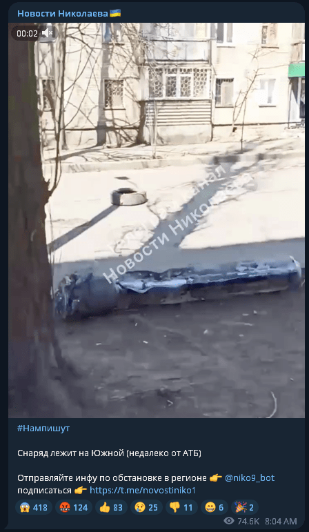
The remains were consistent with 300mm cluster rockets, such as the Type 9M55K, which Bellingkett concluded were among those widely used in Ukraine since the start of the full-scale Russian invasion. These missiles are fired from 300 mm launchers, such as the BM-30 Smerch multiple rocket launcher (MSR).
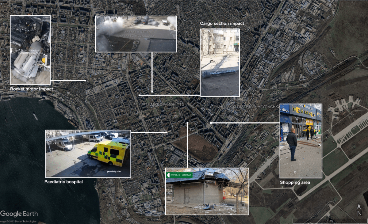
Geolocation images of projectile fragments that appeared on the Internet immediately after the explosion and were plotted on Google Maps showed that the fire was concentrated in the affected area and in the center of Mykolaiv. These drop sites are located along an axis from northwest to southeast, as containers and other parts of the rocket fell to the ground.
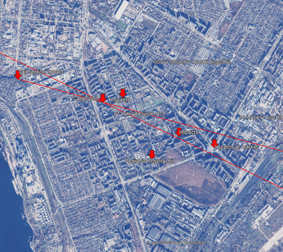
One line is drawn from the drop point of the rocket motor to the landing point of the payload. Another line passes directly through the specified drop point. These lines are not intended to cover the entire drop location, so some drop locations, such as the Children’s Hospital, are outside of these lines. These positions can be used to narrow down possible trajectories and are represented by two red lines.
These lines intersect at the point where the rocket payload was located. After determining the likely weapons systems used, a circle with a diameter of 70 km and 90 km can be drawn around the center of the city.
This is the maximum flight range of a 300 mm cluster rocket, according to the website of the Russian arms export company Rosoboronexport. Thus, the missile that hit Mykolaiv that day was most likely fired from somewhere in the area marked by the red triangle on the map below.
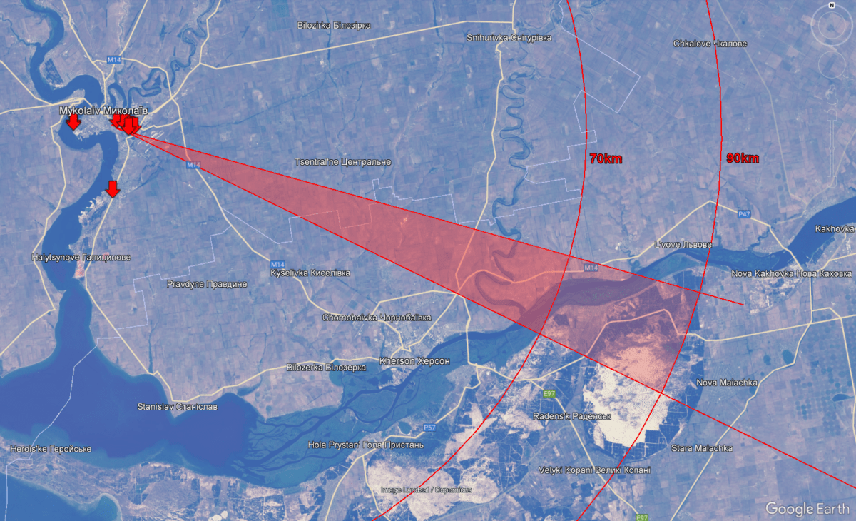
Since the area between Mykolaiv and Kherson was a zone of active hostilities, rocket fire could have taken place there, not recorded in open sources. However, one shelling was recorded.
After it became known about the shelling on April 4, videos began to spread on the Internet, which allegedly recorded firefights from rocket launchers between Kherson and Mykolaiv, which are occupied by Russia.
Some videos posted on Telegram channels on April 4 showed launches from the northern suburbs of the city of Kherson in the direction of Mykolaiv, but they were filmed the day before, as they appeared online shortly after midnight, but depicted the area during daylight hours. These videos were not taken into account for the purposes of determining where the fire was launched later that day.
Other videos that appeared on the popular Telegram channel of Huyovy Kherson were quickly deleted. These videos were archived by Bellingket before they were removed.
However, some of them were later reposted by third parties, so they remained online. For example, at 5:33 p.m. on April 4, the pro-Russian Telegram channel Vvoenkor published two videos that had already been published earlier, with the words “Powerful Russian Smerch or Uragan MLRS are hitting the enemy from Kherson in the direction of Mykolaiv.”
One video showed two buildings below the camera with a solar panel in the foreground. Apparently, the person filming this video was standing on a public road in the village, which we later identified using satellite images. The launcher could be seen in the background, on top of a hill on the other side of the valley from the camera. The silhouette of this launcher is reminiscent of a common Soviet-made multiple rocket launcher (RCMS), such as the BM-30 Smerch.
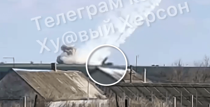
This became a clue as to the direction of the camera, as several channels that reposted the video indicated that they were shooting in Mykolaiv. Also, given the position of the sun, the video appears to have been shot facing south.
If this video was taken within our search area (red triangle above) and within range of the 300mm cluster rocket, it could be a candidate for the launch that hit Mykolaiv that day.
However, since the video may show a different launch and the trajectory shown may be inaccurate, the search was also conducted outside the area marked by the red cone.
At the far end of the 70-kilometer search zone narrowed earlier, they compared the objects on the mapping service and on the video and found a match. The color spots on the roof, the placement of the chimney, the solar panels and the garden area in the foreground allowed us to confirm the match. We now know that the video was taken in the planned launch area marked by the red cones.
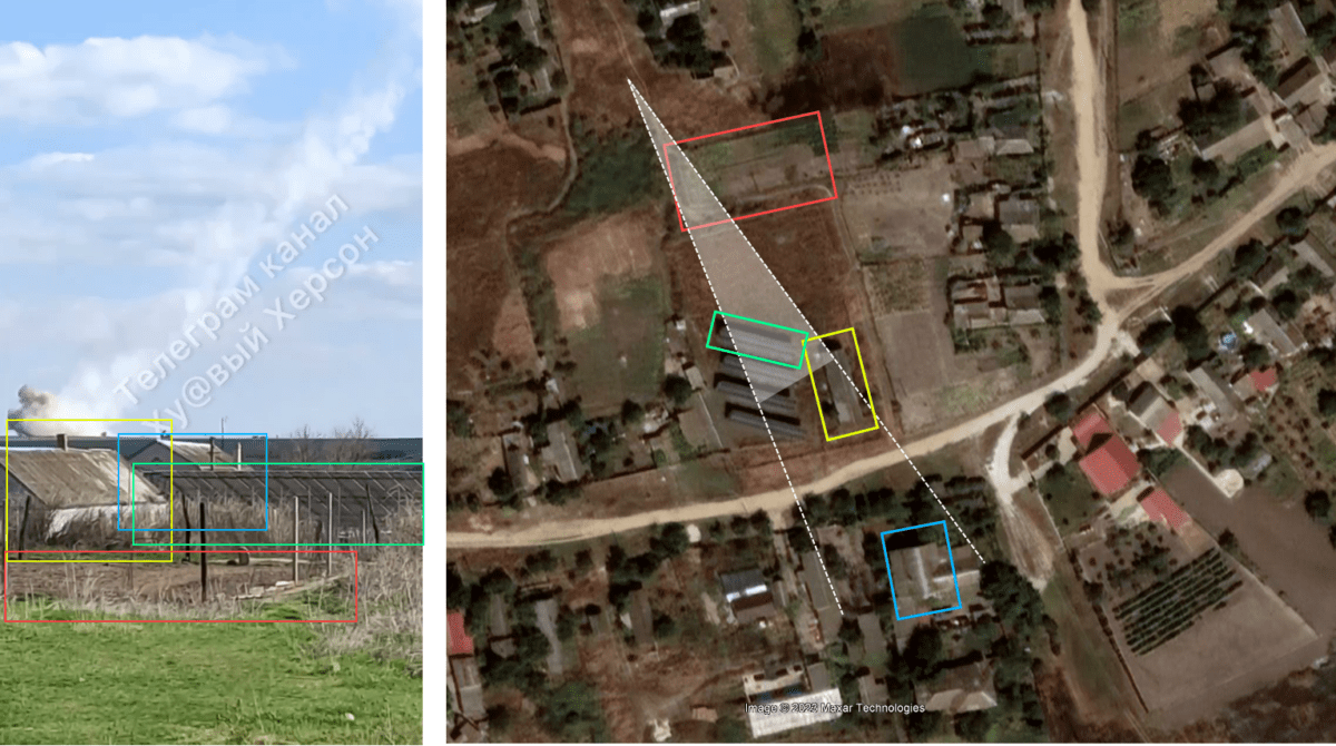
Then we managed to trace the line of sight from the camera from which the photo was taken to the missile launch position on the hill on the other side of the Ingulets River. While looking through historical satellite images from the ArcGIS archive, we saw a distinctive mark near the road connecting the town of Ingulets with the E58 highway.
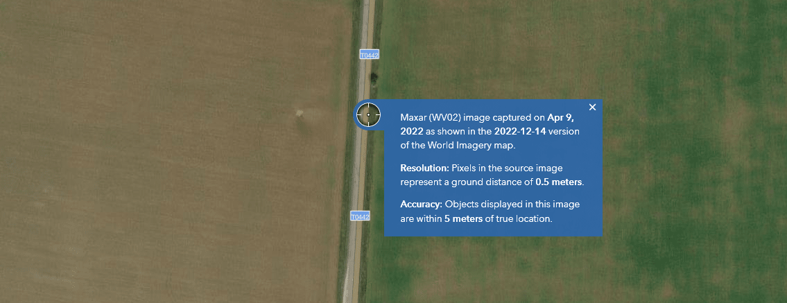
You can see the date of receipt of provided satellite images anywhere on the ArcGIS website. It turns out that the photo with this mark was received on April 9, five days after the video was released.
High-quality images taken before the war did not show this mark. This mark is similar to similar marks found on the ground elsewhere in Ukraine, in areas where missiles were used.
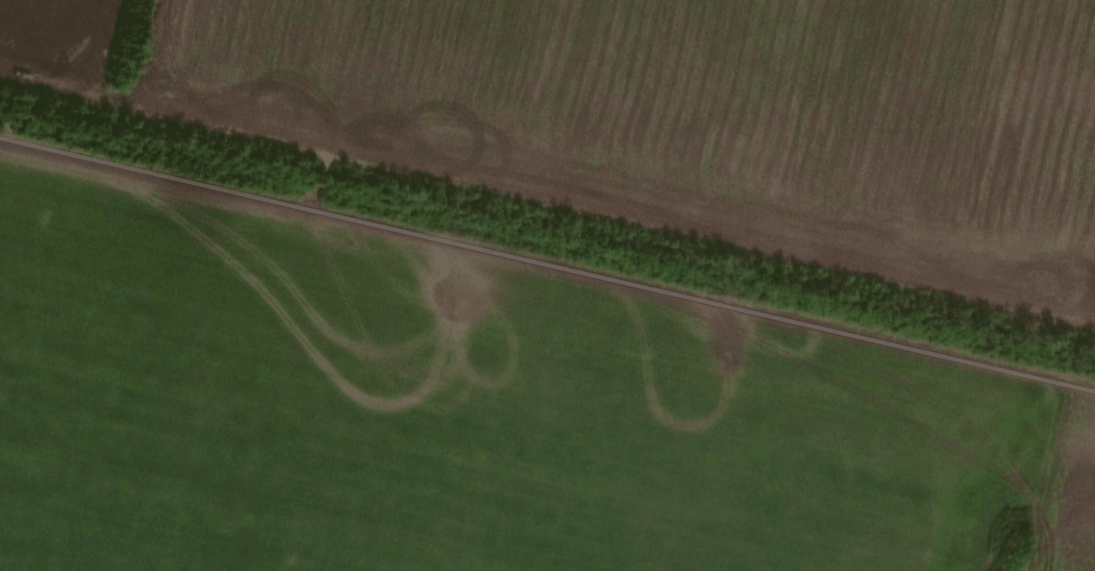
A characteristic feature is the place where traces of the most concentrated rocket explosions are visible, and then diverge in the opposite direction.
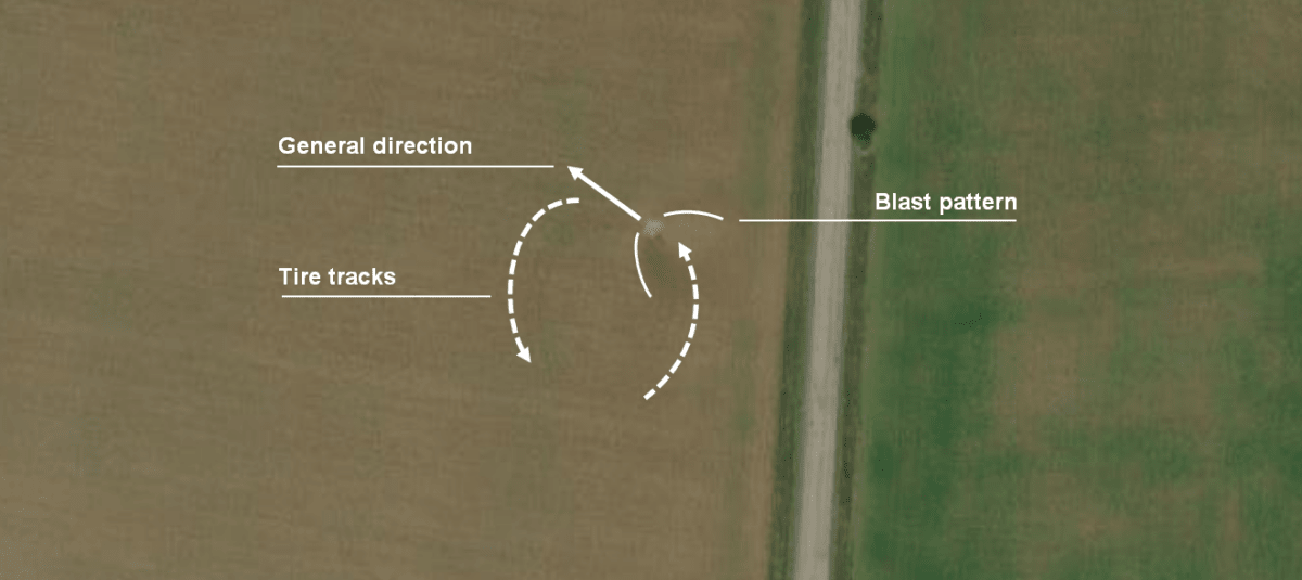
We also noticed tire tracks going north of the road and stopped where the explosion was believed to have occurred. Then these tracks made a U-turn and headed back in the direction they came from.
Using the BlenderGIS plugin for Blender 3D, we were able to reconstruct the scene; the ESRI imagery was fairly new and could certainly be used to image the grass, soil and crops in the field where the launch took place.
However, terrain data from other open sources (such as OpenTopology) was less accurate. As a result, camera lenses could not be perfectly reproduced, and terrain could not be 100% accurate. However, it was possible to create a reasonably acceptable rendering from satellite images using reference images that provided height clues.
Using these elevation marks, we tried to faithfully recreate the scene based on what we were able to see and capture on video. While trying to recreate the scene, we noticed the shadow of a chimney on a distant building.
We tried to use this shadow to estimate the launch time, i.e. when it happened. Since the pitch angle of the roof could only be determined by physically measuring it on site, it was impossible to determine the exact time span. However, it was possible to make an approximate estimate of whether the launch coincides with the 15:30 mark on the video from the Mykolaiv Children’s Hospital.
Using SunCalc, we took the Sun’s elevation (37 degrees) and azimuth (230 degrees) at this location on April 4, 2022 at 3:25 PM and plugged it into the sun disk function in Blender. This is an artificial atmosphere that Blender can generate based on selected inputs, allowing users to visualize the circumstances of their choice.
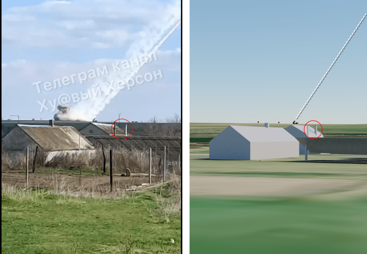
As a result, an almost identical shadow fell on the roofs of the buildings in the background; a visual inspection of the shadow on the map in SunCalc confirmed that the angles were very similar and that the shelling took place during the day, probably during the Nikolaev shelling, with certainty.
At the time the video was shot, according to Liveuamap, an interactive map that is regularly updated with front lines in Ukraine and other conflict zones, the area near the Ingres River was under the operational control of the Russian military.
This makes it extremely unlikely that Ukrainian forces were involved in the launch; Russian troops would not be pushed out of this area before the start of the counteroffensive to retake the Kherson region in early September 2022.